IMAGES TAKEN NEAR TO
Knightswood, WOKING, GU21 3PY
Introduction
This page details the photographs taken nearby to Knightswood, GU21 3PY by members of the Geograph project.
The Geograph project started in 2005 with the aim of publishing, organising and preserving representative images for every square kilometre of Great Britain, Ireland and the Isle of Man.

There are currently over 7.5m images from over14,400 individuals and you can help contribute to the project by visiting https://www.geograph.org.uk
Image Map
Images are licensed for reuse under creativecommons.org/licenses/by-sa/2.0
Notes
- Clicking on the map will re-center to the selected point.
- The higher the marker number, the further away the image location is from the centre of the postcode.
Image Listing (33 Images Found)
Images are licensed for reuse under creativecommons.org/licenses/by-sa/2.0
Image
Details
Distance
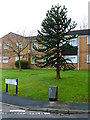
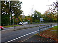
2
Roundabout on Lockfield Drive, St John's
Image: © David Howard
Taken: 9 Oct 2016
0.06 miles

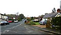
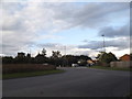
6
A324 Amstel Way, Woking
Towards, rather indirectly, the town centre.
Image: © Robin Webster
Taken: 2 Aug 2020
0.13 miles