IMAGES TAKEN NEAR TO
Martindale Road, WOKING, GU21 3PH
Introduction
This page details the photographs taken nearby to Martindale Road, GU21 3PH by members of the Geograph project.
The Geograph project started in 2005 with the aim of publishing, organising and preserving representative images for every square kilometre of Great Britain, Ireland and the Isle of Man.

There are currently over 7.5m images from over14,400 individuals and you can help contribute to the project by visiting https://www.geograph.org.uk
Image Map
Images are licensed for reuse under creativecommons.org/licenses/by-sa/2.0
Notes
- Clicking on the map will re-center to the selected point.
- The higher the marker number, the further away the image location is from the centre of the postcode.
Image Listing (101 Images Found)
Images are licensed for reuse under creativecommons.org/licenses/by-sa/2.0
Image
Details
Distance
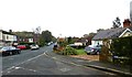
4
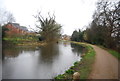
Robin Hood Road, St John's
Suburban housing on the outskirts of Woking; it is evidently bin day.
Image: © Stephen McKay
Taken: 29 Aug 2019
0.11 miles
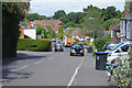
5
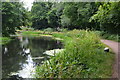
Basingstoke Canal at St John's
Looking towards Redway Lock.
Image: © David Martin
Taken: 1 Jul 2017
0.11 miles
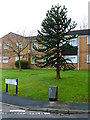
9
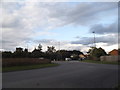
Roundabout on Lockfield Drive, St John's
Image: © David Howard
Taken: 9 Oct 2016
0.12 miles
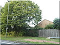
10
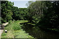
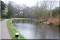
Basingstoke Canal
Just east of Kiln Bridge.
Image: © Peter Trimming
Taken: 29 Jun 2019
0.12 miles