IMAGES TAKEN NEAR TO
Westmead, WOKING, GU21 3BS
Introduction
This page details the photographs taken nearby to Westmead, GU21 3BS by members of the Geograph project.
The Geograph project started in 2005 with the aim of publishing, organising and preserving representative images for every square kilometre of Great Britain, Ireland and the Isle of Man.

There are currently over 7.5m images from over14,400 individuals and you can help contribute to the project by visiting https://www.geograph.org.uk
Image Map
Images are licensed for reuse under creativecommons.org/licenses/by-sa/2.0
Notes
- Clicking on the map will re-center to the selected point.
- The higher the marker number, the further away the image location is from the centre of the postcode.
Image Listing (45 Images Found)
Images are licensed for reuse under creativecommons.org/licenses/by-sa/2.0
Image
Details
Distance
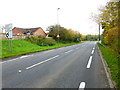
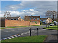
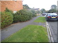
1
A324 Lockfield Drive
Towards central Woking.
Image: © Robin Webster
Taken: 2 Aug 2020
0.06 miles
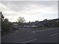
3
Goldsworth Park, Sythwood
Sythwood, one of the main thoroughfares through Goldsworth Park with the junction of Venton Close on the right.
Image: © Alan Hunt
Taken: 18 Apr 2013
0.11 miles
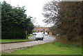
4
Roffords at the junction of Marston Road
Image: © David Howard
Taken: 16 Oct 2016
0.12 miles
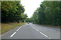
5
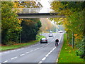
Looking eastwards on Lockfield Drive with footbridge ahead
Image: © Shazz
Taken: 16 Nov 2014
0.13 miles
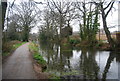
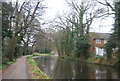
8
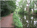
Basingstoke Canal, Woking
View of the canal near Parley Drive Bridge looking towards Woking
Image: © Richard Rogerson
Taken: 19 Aug 2021
0.13 miles