IMAGES TAKEN NEAR TO
Warbury Lane, WOKING, GU21 2TT
Introduction
This page details the photographs taken nearby to Warbury Lane, GU21 2TT by members of the Geograph project.
The Geograph project started in 2005 with the aim of publishing, organising and preserving representative images for every square kilometre of Great Britain, Ireland and the Isle of Man.

There are currently over 7.5m images from over14,400 individuals and you can help contribute to the project by visiting https://www.geograph.org.uk
Image Map
Images are licensed for reuse under creativecommons.org/licenses/by-sa/2.0
Notes
- Clicking on the map will re-center to the selected point.
- The higher the marker number, the further away the image location is from the centre of the postcode.
Image Listing (51 Images Found)
Images are licensed for reuse under creativecommons.org/licenses/by-sa/2.0
Image
Details
Distance
1
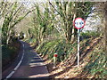
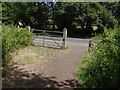
Warberry Lane
Narrow one-way country lane between Bisley and Knaphill. The trees along it have been coppiced.
Image: © Colin Smith
Taken: 28 Nov 2009
0.05 miles
2
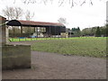
Stables, Knaphill
The view from the footpath south of Kiln Lane towards the stables on Warbury Lane.
Image: © Alan Hunt
Taken: 27 Nov 2015
0.05 miles
3
Barn, Hill Place Farm
Large metal barn at Hill Place Farm, between Bisley and Knaphill.
Image: © Paul E Smith
Taken: 5 Feb 2011
0.06 miles
4
Track, Hill Place Farm
The access track that leads from Warbury Lane to the Chobham Road.
Image: © Alan Hunt
Taken: 8 Dec 2013
0.09 miles
5
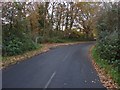
Kiln Lane
The junction of Kiln Lane with Warbury Lane. Although most of Kiln Lane is in Bisley Parish, these last few yards are in Knaphill.
Image: © Alan Hunt
Taken: 4 Jul 2010
0.10 miles
6
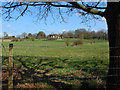
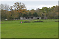
Hill Place Farm
Looking across the fields towards Hill Place Farm from Warbury Lane
Image: © Alan Hunt
Taken: 23 Apr 2013
0.10 miles
7
Church Lane
Looking north along Church Lane. The entrance to Kiln Lane, a footpath that runs to the Bagshot Road, is on the left by the gate.
Image: © Alan Hunt
Taken: 8 Dec 2013
0.10 miles
8
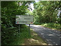
Bisley Village sign
The entrance to Bisley Village. The road changes its name from Warbury Lane (Knaphill) to Church Lane (Bisley) at this point. Bisley is one of the six villages of Surrey Heath, the others being West End, Lightwater, Bagshot, Windlesham and Chobham.
Image: © Alan Hunt
Taken: 4 Jul 2010
0.11 miles
9
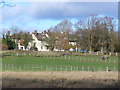
Hill Place
Large farm on green belt land north-west of Woking, close to the suburban sprawl of Knaphill.
Image: © Colin Smith
Taken: 28 Nov 2009
0.11 miles
10
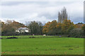
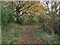
Farmland off Warbury Lane
The fields to the west of Warbury Lane viewed from the footpath from Kiln Lane to the Chobham Road.
Image: © Alan Hunt
Taken: 27 Nov 2015
0.12 miles