IMAGES TAKEN NEAR TO
Cavell Way, WOKING, GU21 2TJ
Introduction
This page details the photographs taken nearby to Cavell Way, GU21 2TJ by members of the Geograph project.
The Geograph project started in 2005 with the aim of publishing, organising and preserving representative images for every square kilometre of Great Britain, Ireland and the Isle of Man.

There are currently over 7.5m images from over14,400 individuals and you can help contribute to the project by visiting https://www.geograph.org.uk
Image Map
Images are licensed for reuse under creativecommons.org/licenses/by-sa/2.0
Notes
- Clicking on the map will re-center to the selected point.
- The higher the marker number, the further away the image location is from the centre of the postcode.
Image Listing (44 Images Found)
Images are licensed for reuse under creativecommons.org/licenses/by-sa/2.0
Image
Details
Distance
1
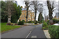
Cavell Way, Knaphill
The access road off Redding Way to the main building of the former Brookwood Mental Asylum converted to flats in the early 1990s and renamed Florence Court.
Image: © Alan Hunt
Taken: 17 Nov 2015
0.06 miles
2
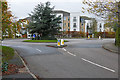
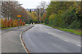
Cavell Way, Knaphill
The roundabout at the junction of Cavell Way with Redding Way.
Image: © Alan Hunt
Taken: 17 Nov 2015
0.07 miles
3
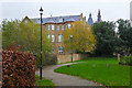
Florence Court, Knaphill
The former Brookwood Asylum now converted into flats, viewed from the small recreation ground off Redding Way.
Image: © Alan Hunt
Taken: 17 Nov 2015
0.08 miles
4
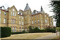
Knaphill - Former Brookwood Hospital
Brookwood Hospital was opened in 1867 under the title Brookwood Asylum and later, in 1919, changed its name to Brookwood Mental Hospital. Today the buildings remaining have been converted into apartments.
Image: © Colin Smith
Taken: 21 Jul 2018
0.08 miles
5

Knaphill - Former Brookwood Hospital
Brookwood Hospital was opened in 1867 under the title Brookwood Asylum and later, in 1919, changed its name to Brookwood Mental Hospital. Today the buildings remaining have been converted into apartments.
Image: © Colin Smith
Taken: 21 Jul 2018
0.08 miles
6
Redding Way, Knaphill
Looking east from the roundabout at the entrance to the Sainsbury superstore.
Image: © Alan Hunt
Taken: 17 Nov 2015
0.09 miles
7
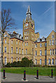
Former Brookwood Hospital
The clock tower of this imposing Victorian mental hospital that existed on this site between 1867 and 1994. The site formerly covered 150 acres and was a self contained community with a 12 acre farm, shops and even its own fire brigade. There were 650 patients when first opened with a peak number of 1900 by 1947. Closed in 1994 the original buildings, now listed, have been converted to flats. Many of the old ward blocks have been demolished to make way for housing and a Sainsbury's supermarket.
Image: © Alan Hunt
Taken: 22 Apr 2013
0.09 miles
8

Brookwood Hospital
The eastern end of the former reception block of this former Victorian mental hospital. Closed in 1994 the block has been converted to flats.
Image: © Alan Hunt
Taken: 22 Apr 2013
0.11 miles
9
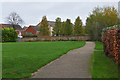
Redding Way recreation area
A small recreation area off Redding Way with the houses on the former Brookwood Mental Asylum in the background.
Image: © Alan Hunt
Taken: 17 Nov 2015
0.11 miles
10
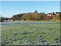
Brookwood Country Park
Looking across the recreation area after a hard overnight frost.
Image: © Alan Hunt
Taken: 29 Dec 2014
0.11 miles