IMAGES TAKEN NEAR TO
Broadway, WOKING, GU21 2SP
Introduction
This page details the photographs taken nearby to Broadway, GU21 2SP by members of the Geograph project.
The Geograph project started in 2005 with the aim of publishing, organising and preserving representative images for every square kilometre of Great Britain, Ireland and the Isle of Man.

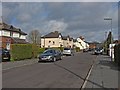
There are currently over 7.5m images from over14,400 individuals and you can help contribute to the project by visiting https://www.geograph.org.uk
Image Map
Images are licensed for reuse under creativecommons.org/licenses/by-sa/2.0
Notes
- Clicking on the map will re-center to the selected point.
- The higher the marker number, the further away the image location is from the centre of the postcode.
Image Listing (55 Images Found)
Images are licensed for reuse under creativecommons.org/licenses/by-sa/2.0
Image
Details
Distance
1
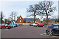
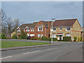
The Vyne car park
The car park for The Vyne community centre with the new-built housing on the Broadway beyond. These houses had only recently been completed at the time of this photograph.
Image: © Alan Hunt
Taken: 13 Jan 2016
0.04 miles
2
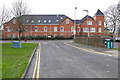
The Grange, Knaphill
Looking down Alexandra Gardens towards The Grange, a block of flats on the site of the former Brookwood Hospital.
Image: © Alan Hunt
Taken: 13 Jan 2016
0.06 miles
3
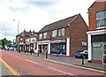
The Broadway, Knaphill
The straight road that runs from the town centre to the Bagshot Road.
Image: © Alan Hunt
Taken: 16 Apr 2013
0.08 miles
4
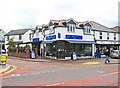
Valentino's, Broadway, Knaphill
On the corner of Queens Road and Broadway is Valentino's Coffee & Juice Bar. It is owned by the business next door, Valentino Schoolwear, although the shopfront of that says Griffiths by Valentino. The schoolwear business has been going in Knaphill since 1939.
Image: © P L Chadwick
Taken: 20 Jun 2011
0.08 miles
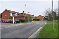
5
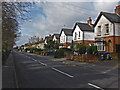
Sussex Road, Knaphill
A short residential road dating from the 1920s that runs between the Broadway and the High Street.
Image: © Alan Hunt
Taken: 16 Apr 2013
0.09 miles
6
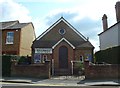
Knaphill Baptist Church: early September 2015
Image: © Basher Eyre
Taken: 7 Sep 2015
0.09 miles
7
Alexandra Gardens, Knaphill
This road is part of the Brookwood Hospital developmentfrom the 1990s when the old mental asylum was closed down.
Image: © Alan Hunt
Taken: 13 Jan 2016
0.09 miles
8
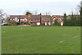
The Vyne playing fields, Knaphill
The playing fields with the houses along Alexandra gardens beyond.
Image: © Alan Hunt
Taken: 13 Jan 2016
0.11 miles
9
Shops in High Street, Knaphill
Amongst the shops here are Keith Henderson Sports, and Dragon Inn, a Chinese take-away. To the right of that, is part of the premises of David Evans & Co, a firm of specialised property lawyers.
Image: © P L Chadwick
Taken: 20 Jun 2011
0.11 miles
10
Florence Way, Knaphill
Built on the former Brookwood Hospital site in the late 1990s, the roads in this estate all have names connected with the old hospital. This one is named after one of the main wards.
Image: © Alan Hunt
Taken: 22 Apr 2013
0.11 miles