IMAGES TAKEN NEAR TO
Alanbrooke Close, WOKING, GU21 2RU
Introduction
This page details the photographs taken nearby to Alanbrooke Close, GU21 2RU by members of the Geograph project.
The Geograph project started in 2005 with the aim of publishing, organising and preserving representative images for every square kilometre of Great Britain, Ireland and the Isle of Man.

There are currently over 7.5m images from over14,400 individuals and you can help contribute to the project by visiting https://www.geograph.org.uk
Image Map
Images are licensed for reuse under creativecommons.org/licenses/by-sa/2.0
Notes
- Clicking on the map will re-center to the selected point.
- The higher the marker number, the further away the image location is from the centre of the postcode.
Image Listing (45 Images Found)
Images are licensed for reuse under creativecommons.org/licenses/by-sa/2.0
Image
Details
Distance
1
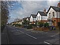
The Broadway, Knaphill
The straight road that runs from the town centre to the Bagshot Road.
Image: © Alan Hunt
Taken: 16 Apr 2013
0.05 miles
2
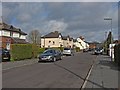
Sussex Road, Knaphill
A short residential road dating from the 1920s that runs between the Broadway and the High Street.
Image: © Alan Hunt
Taken: 16 Apr 2013
0.09 miles