IMAGES TAKEN NEAR TO
Shirley Place, WOKING, GU21 2PL
Introduction
This page details the photographs taken nearby to Shirley Place, GU21 2PL by members of the Geograph project.
The Geograph project started in 2005 with the aim of publishing, organising and preserving representative images for every square kilometre of Great Britain, Ireland and the Isle of Man.

There are currently over 7.5m images from over14,400 individuals and you can help contribute to the project by visiting https://www.geograph.org.uk
Image Map
Images are licensed for reuse under creativecommons.org/licenses/by-sa/2.0
Notes
- Clicking on the map will re-center to the selected point.
- The higher the marker number, the further away the image location is from the centre of the postcode.
Image Listing (41 Images Found)
Images are licensed for reuse under creativecommons.org/licenses/by-sa/2.0
Image
Details
Distance
1
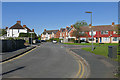
Highclere Road, Knaphill
Looking northwest along Highclere Road from near the junction with the High Street.
Image: © Alan Hunt
Taken: 5 Oct 2016
0.07 miles
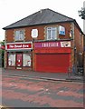
2
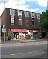
Knaphill Food & Wine, 5 High Street, Knaphill
A local convenience store. Next door is an empty shop unit currently to let, and upstairs are empty offices, also to let.
Image: © P L Chadwick
Taken: 20 Jun 2011
0.10 miles
3
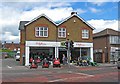
Cliftons Turf Machinery Limited, 15 High Street, Knaphill
This company was established in the 1960's. They stock a wide range of lawn machinery, not just lawnmowers. They also provide servicing and have a large stock of spare parts.
Image: © P L Chadwick
Taken: 20 Jun 2011
0.11 miles
4
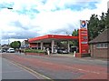
Total filling station and convenience store, High Street, Knaphill
Located in the centre of Knaphill.
Image: © P L Chadwick
Taken: 20 Jun 2011
0.12 miles
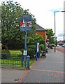
5
Knaphill village sign (close-up), High Street, Knaphill
The location of the sign, near information boards and seats:- Image
Image: © P L Chadwick
Taken: 20 Jun 2011
0.12 miles
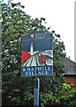
6
Knaphill village sign, High Street, Knaphill
The sign has been placed here by Woking Borough Council. A closer view:- Image
Image: © P L Chadwick
Taken: 20 Jun 2011
0.12 miles
7
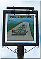
The Anchor (3) - sign, Lower Guildford Road, Knaphill
The sign appears to show an anchor lashed down to the top of a canal narrowboat. The anchor looks much too big for a boat of this type. The nearest canal is the Basingstoke Canal, which runs to the south of Knaphill, and opened in 1794.
Image
Image
Image: © P L Chadwick
Taken: 20 Jun 2011
0.13 miles
8
The Anchor (2), Lower Guildford Road, Knaphill
Image: © P L Chadwick
Taken: 20 Jun 2011
0.13 miles
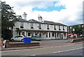
9
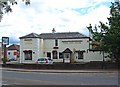
The Anchor (1), Lower Guildford Road, Knaphill
A large popular pub, sometimes with live music. Located on the corner of Lower Guildford Road and High Street. The picture shows the High Street side.
Image
Image
Image: © P L Chadwick
Taken: 20 Jun 2011
0.13 miles
10
The Bead Box and Threshers, 22 & 24 High Street, Knaphill
The Bead Shop at 22 High Street sells beads and other supplies for making jewellery. It also runs tuition classes in making your own. Threshers at 24 High Street, used to be an off-licence, selling wines, beers and spirits. It was part of a larger group, called First Quench, which collapsed in late 2009. This branch closed just before Christmas 2009. A year and a half later, the property is still empty and to let. Although a few branches of Threshers were sold to other off-licence groups, quite a lot of their former branches are in the same position as this one.
Image: © P L Chadwick
Taken: 20 Jun 2011
0.13 miles