IMAGES TAKEN NEAR TO
Meyrick Close, WOKING, GU21 2PA
Introduction
This page details the photographs taken nearby to Meyrick Close, GU21 2PA by members of the Geograph project.
The Geograph project started in 2005 with the aim of publishing, organising and preserving representative images for every square kilometre of Great Britain, Ireland and the Isle of Man.

There are currently over 7.5m images from over14,400 individuals and you can help contribute to the project by visiting https://www.geograph.org.uk
Image Map
Images are licensed for reuse under creativecommons.org/licenses/by-sa/2.0
Notes
- Clicking on the map will re-center to the selected point.
- The higher the marker number, the further away the image location is from the centre of the postcode.
Image Listing (26 Images Found)
Images are licensed for reuse under creativecommons.org/licenses/by-sa/2.0
Image
Details
Distance
1
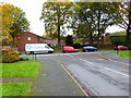
Lockfield Drive
The junction of Creston Avenue with Lockfield Drive.
Image: © Alan Hunt
Taken: 14 Apr 2013
0.04 miles
2
Chequer Tree Close
This close built during the 1970s from the junction with Creston Avenue.
Image: © Alan Hunt
Taken: 14 Apr 2013
0.06 miles
3
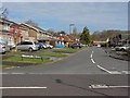
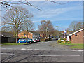
Creston Avenue
The housing estates around Creston Avenue were built during the mid 1970s. There are allotments to the left of where the bus is stopped.
Image: © Alan Hunt
Taken: 14 Apr 2013
0.06 miles
5
Semper Close, Knaphill
One of the side roads off Creston Avenue.
Image: © Alan Hunt
Taken: 14 Apr 2013
0.12 miles
6
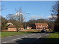
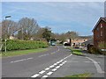
Whitfield court
Littlewick Road with the buildings of Whitfield court in the background. This is one of the oldest buildings in Knaphill. Originally a farm dating from the 16th century, the buildings were remodelled and extended in the 18th & 19th centuries.
Image: © Alan Hunt
Taken: 20 Feb 2010
0.14 miles
7
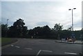
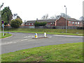
Roundabout on Littlewick Road, Knaphill
Image: © David Howard
Taken: 1 Sep 2013
0.14 miles
8
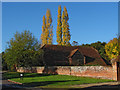
Whitfield Court
One of the barns of Whitfield Court with Lombardy Poplars in fine autumn colour in the background.
Image: © Alan Hunt
Taken: 15 Nov 2013
0.16 miles
9
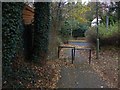
Walkway, goldsworth Park
The short walkway from Rainbow Court to Littlewick Road on the edge of Goldsworth Park
Image: © Alan Hunt
Taken: 5 Dec 2013
0.16 miles
10
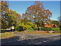
Barrs lane junction
The junction of Barrs lane with Littlewick Road. This much used road runs from here to the Chobham Road. Waterers Park recereation ground is on the left.
Image: © Alan Hunt
Taken: 15 Nov 2013
0.17 miles