IMAGES TAKEN NEAR TO
Robin Hood Road, WOKING, GU21 2LY
Introduction
This page details the photographs taken nearby to Robin Hood Road, GU21 2LY by members of the Geograph project.
The Geograph project started in 2005 with the aim of publishing, organising and preserving representative images for every square kilometre of Great Britain, Ireland and the Isle of Man.

There are currently over 7.5m images from over14,400 individuals and you can help contribute to the project by visiting https://www.geograph.org.uk
Image Map
Images are licensed for reuse under creativecommons.org/licenses/by-sa/2.0
Notes
- Clicking on the map will re-center to the selected point.
- The higher the marker number, the further away the image location is from the centre of the postcode.
Image Listing (20 Images Found)
Images are licensed for reuse under creativecommons.org/licenses/by-sa/2.0
Image
Details
Distance
1
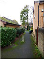
Footpath, Inkerman Woods
The bottom end of the footpath linking Robin Hood Road and Raglan Road, The site of the former Inkerman Barracks.
Image: © Alan Hunt
Taken: 9 Jan 2010
0.06 miles
2
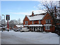
The Robin Hood , Knaphill
A pub on Robin Hood Road that would have been much used by the soldiers at the Inkerman Barracks which once occupied a site at the top of the hill above Robin Hood Road. The barracks went in the 1960's but the pub still thrives.
Image: © Alan Hunt
Taken: 9 Jan 2010
0.06 miles
3
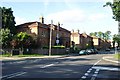
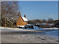
Inkerman Barracks
A couple of rows of Victorian houses are all that remain of the Inkerman Barracks. Built as a prison for infirm convicts in 1860, the buildings were taken over by the army in 1895 and renamed the Inkerman Barracks after the Crimean War battle. The main part of the barracks has been demolished and replaced by modern housing.
Image: © Ron Strutt
Taken: 29 Aug 2005
0.12 miles
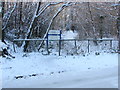
4
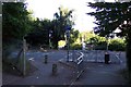
Cycle crossing at Amstel Way
This cycle crossing provides a safe route from St Johns to the large Winston Churchill School, which is just behind the photographer.
Image: © Ron Strutt
Taken: 29 Aug 2005
0.12 miles
5
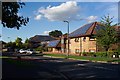
Energy conservation in Woking
Woking has taken a leading role in energy conservation developments. At Denton Way on the Goldsworth Park estate these buildings are fitted with photovoltaic units to generate their own electricity.
Image: © Ron Strutt
Taken: 29 Aug 2005
0.12 miles
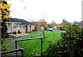
7
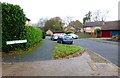
Locksley Drive, Knaphill
The Junction between Robin Hood Road and Locksley Drive. Locksley Drive was created in the 1980's to connect Knaphill and Woking and provide a feeder road for the Goldsworth Park Estate. Robin Hood Road used to connect the villages of Knaphill and St Johns but is now bisected by the St Johns bypass.
Image: © Alan Hunt
Taken: 9 Jan 2010
0.14 miles
8
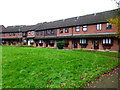
Terraced crescent of houses on Nethercote Avenue
Image: © Shazz
Taken: 16 Nov 2014
0.15 miles