IMAGES TAKEN NEAR TO
Highclere Gardens, WOKING, GU21 2LR
Introduction
This page details the photographs taken nearby to Highclere Gardens, GU21 2LR by members of the Geograph project.
The Geograph project started in 2005 with the aim of publishing, organising and preserving representative images for every square kilometre of Great Britain, Ireland and the Isle of Man.

There are currently over 7.5m images from over14,400 individuals and you can help contribute to the project by visiting https://www.geograph.org.uk
Image Map
Images are licensed for reuse under creativecommons.org/licenses/by-sa/2.0
Notes
- Clicking on the map will re-center to the selected point.
- The higher the marker number, the further away the image location is from the centre of the postcode.
Image Listing (49 Images Found)
Images are licensed for reuse under creativecommons.org/licenses/by-sa/2.0
Image
Details
Distance
1
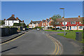
Highclere Road, Knaphill
Looking northwest along Highclere Road from near the junction with the High Street.
Image: © Alan Hunt
Taken: 5 Oct 2016
0.06 miles
2
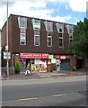
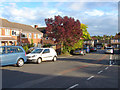
Knaphill Food & Wine, 5 High Street, Knaphill
A local convenience store. Next door is an empty shop unit currently to let, and upstairs are empty offices, also to let.
Image: © P L Chadwick
Taken: 20 Jun 2011
0.09 miles
3
Optiplan, Coombe Villa, Anchor Hill, Knaphill
Optiplan provide bespoke kitchens. They were established in 1984, and have several branches. The Knaphill branch was opened in 2007. Prior to that, the premises were occupied by a firm called Millwood DIY.
Image: © P L Chadwick
Taken: 20 Jun 2011
0.10 miles
4
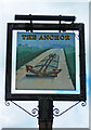
The Anchor (3) - sign, Lower Guildford Road, Knaphill
The sign appears to show an anchor lashed down to the top of a canal narrowboat. The anchor looks much too big for a boat of this type. The nearest canal is the Basingstoke Canal, which runs to the south of Knaphill, and opened in 1794.
Image
Image
Image: © P L Chadwick
Taken: 20 Jun 2011
0.10 miles
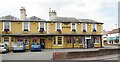
5
The Anchor (2), Lower Guildford Road, Knaphill
Image: © P L Chadwick
Taken: 20 Jun 2011
0.10 miles
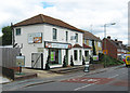
6
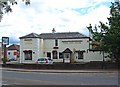
The Anchor (1), Lower Guildford Road, Knaphill
A large popular pub, sometimes with live music. Located on the corner of Lower Guildford Road and High Street. The picture shows the High Street side.
Image
Image
Image: © P L Chadwick
Taken: 20 Jun 2011
0.10 miles
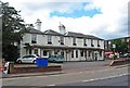
7
Knaphill - The Anchor
Large pub in suburban Woking, at the corner of Knaphill High Street and Lower Guildford Road.
Image: © Colin Smith
Taken: 21 Jul 2018
0.11 miles
8
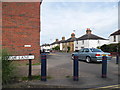
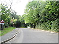
Anchor Hill at the junction of Barley Mow Lane
Image: © David Howard
Taken: 1 Sep 2013
0.11 miles
10
Barley Mow Lane
The "town" end of Barley Mow Lane which runs from Anchor Hill to the Chobham Road.
Image: © Alan Hunt
Taken: 1 Oct 2012
0.11 miles