IMAGES TAKEN NEAR TO
Littlewick Road, WOKING, GU21 2JU
Introduction
This page details the photographs taken nearby to Littlewick Road, GU21 2JU by members of the Geograph project.
The Geograph project started in 2005 with the aim of publishing, organising and preserving representative images for every square kilometre of Great Britain, Ireland and the Isle of Man.

There are currently over 7.5m images from over14,400 individuals and you can help contribute to the project by visiting https://www.geograph.org.uk
Image Map
Images are licensed for reuse under creativecommons.org/licenses/by-sa/2.0
Notes
- Clicking on the map will re-center to the selected point.
- The higher the marker number, the further away the image location is from the centre of the postcode.
Image Listing (20 Images Found)
Images are licensed for reuse under creativecommons.org/licenses/by-sa/2.0
Image
Details
Distance
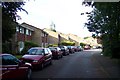
1
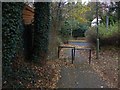
Walkway, goldsworth Park
The short walkway from Rainbow Court to Littlewick Road on the edge of Goldsworth Park
Image: © Alan Hunt
Taken: 5 Dec 2013
0.04 miles
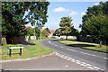
2
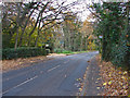
Littlewick Road
Looking east along Littlewick Road.
Image: © Alan Hunt
Taken: 5 Dec 2013
0.05 miles
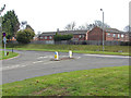
3
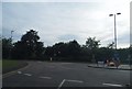
Roundabout on Littlewick Road, Knaphill
Image: © David Howard
Taken: 1 Sep 2013
0.06 miles
4
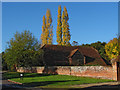
Whitfield Court
One of the barns of Whitfield Court with Lombardy Poplars in fine autumn colour in the background.
Image: © Alan Hunt
Taken: 15 Nov 2013
0.12 miles
5
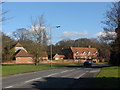
Whitfield court
Littlewick Road with the buildings of Whitfield court in the background. This is one of the oldest buildings in Knaphill. Originally a farm dating from the 16th century, the buildings were remodelled and extended in the 18th & 19th centuries.
Image: © Alan Hunt
Taken: 20 Feb 2010
0.13 miles
6
Chequer Tree Close
This close built during the 1970s from the junction with Creston Avenue.
Image: © Alan Hunt
Taken: 14 Apr 2013
0.14 miles
7
Lockfield Drive
The junction of Creston Avenue with Lockfield Drive.
Image: © Alan Hunt
Taken: 14 Apr 2013
0.15 miles
8
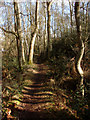
Littlewick Common
Woodland path running across Littlewick Common.
Image: © Alan Hunt
Taken: 20 Feb 2010
0.18 miles
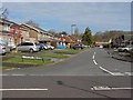
9
Kirkland Avenue, Goldsworth Park
This is one of the distributor roads for the Goldsworth Park Estate.
Image: © Ron Strutt
Taken: 29 Aug 2005
0.18 miles
10
Roundthorn Way, Goldsworth Park
From the Woking Borough Council website: "Goldsworth Park is a large housing development built during the 1970's and 1980's which lies to the west of Woking town centre and the recreation ground. The recreation ground features Goldsworth Park Lake which includes a water sport facility and adds character to the area. A supermarket, shops and other facilities are available at the Goldsworth Park Centre. The estate contains a variety of house types and sizes including bungalows, detached and semi-detached homes. Beyond the Goldsworth Park estate there are older properties and a small trading estate towards Woking town centre."
Image: © Ron Strutt
Taken: 29 Aug 2005
0.18 miles