IMAGES TAKEN NEAR TO
Littlewick Road, WOKING, GU21 2JL
Introduction
This page details the photographs taken nearby to Littlewick Road, GU21 2JL by members of the Geograph project.
The Geograph project started in 2005 with the aim of publishing, organising and preserving representative images for every square kilometre of Great Britain, Ireland and the Isle of Man.

There are currently over 7.5m images from over14,400 individuals and you can help contribute to the project by visiting https://www.geograph.org.uk
Image Map
Images are licensed for reuse under creativecommons.org/licenses/by-sa/2.0
Notes
- Clicking on the map will re-center to the selected point.
- The higher the marker number, the further away the image location is from the centre of the postcode.
Image Listing (34 Images Found)
Images are licensed for reuse under creativecommons.org/licenses/by-sa/2.0
Image
Details
Distance
1
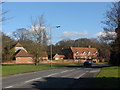
Whitfield court
Littlewick Road with the buildings of Whitfield court in the background. This is one of the oldest buildings in Knaphill. Originally a farm dating from the 16th century, the buildings were remodelled and extended in the 18th & 19th centuries.
Image: © Alan Hunt
Taken: 20 Feb 2010
0.04 miles
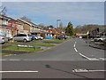
2
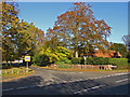
Barrs lane junction
The junction of Barrs lane with Littlewick Road. This much used road runs from here to the Chobham Road. Waterers Park recereation ground is on the left.
Image: © Alan Hunt
Taken: 15 Nov 2013
0.05 miles
3
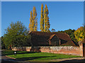
Whitfield Court
One of the barns of Whitfield Court with Lombardy Poplars in fine autumn colour in the background.
Image: © Alan Hunt
Taken: 15 Nov 2013
0.06 miles
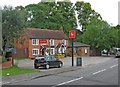
4
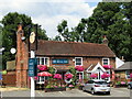
Knaphill - The Royal Oak
Fine old pub at the east end of Anchor Hill.
Image: © Colin Smith
Taken: 21 Jul 2018
0.10 miles
5
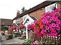
Knaphill - The Royal Oak
Fine old pub with beautiful floral display, sited at the east end of Anchor Hill.
Image: © Colin Smith
Taken: 21 Jul 2018
0.10 miles
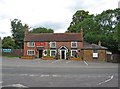
6
Royal Oak (2), Anchor Hill, Knaphill
On the edge of Knaphill, the Royal Oak still has a traditional Courage Brewery sign on a post outside. There are fewer and fewer of these to be seen nowadays.
Image
Image: © P L Chadwick
Taken: 20 Jun 2011
0.10 miles
7
Royal Oak (1), Anchor Hill, Knaphill
The building is about four hundred years old, but may not have been a pub for all that period.
Image
Image: © P L Chadwick
Taken: 20 Jun 2011
0.10 miles
8
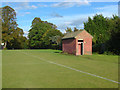
Waterer's Park, Knaphill
The public convenience on the edge of the football pitch.
Image: © Alan Hunt
Taken: 1 Oct 2012
0.11 miles
9
Chequer Tree Close
This close built during the 1970s from the junction with Creston Avenue.
Image: © Alan Hunt
Taken: 14 Apr 2013
0.11 miles
10
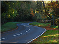
Barrs Lane, Knaphill
Barrs Lane with the former Knaphill Nursery marked by the fence on the right.The original weeping beech to be brought to this country is to be found in the private arboretum at the back of this nursery which was started in the 19th century. The former buildings have been converted to private housing.
Image: © Alan Hunt
Taken: 15 Nov 2013
0.11 miles