IMAGES TAKEN NEAR TO
Barley Mow Lane, WOKING, GU21 2HX
Introduction
This page details the photographs taken nearby to Barley Mow Lane, GU21 2HX by members of the Geograph project.
The Geograph project started in 2005 with the aim of publishing, organising and preserving representative images for every square kilometre of Great Britain, Ireland and the Isle of Man.

There are currently over 7.5m images from over14,400 individuals and you can help contribute to the project by visiting https://www.geograph.org.uk
Image Map
Images are licensed for reuse under creativecommons.org/licenses/by-sa/2.0
Notes
- Clicking on the map will re-center to the selected point.
- The higher the marker number, the further away the image location is from the centre of the postcode.
Image Listing (44 Images Found)
Images are licensed for reuse under creativecommons.org/licenses/by-sa/2.0
Image
Details
Distance
2
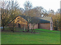
Sports hall, Waterer's Park
The sports hall by the car park at the western end of Waterer's Park recreation and sports ground in Knaphill.
Image: © Alan Hunt
Taken: 5 Feb 2015
0.05 miles
3
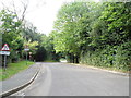
Barley Mow Lane
The "town" end of Barley Mow Lane which runs from Anchor Hill to the Chobham Road.
Image: © Alan Hunt
Taken: 1 Oct 2012
0.05 miles
4
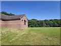
Woking and Horsell Cricket Clubhouse
Waterers Park is on the edge of Knaphill.
Image: © James Emmans
Taken: 1 Jun 2020
0.05 miles
5
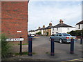
Anchor Hill at the junction of Barley Mow Lane
Image: © David Howard
Taken: 1 Sep 2013
0.06 miles
6
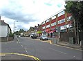
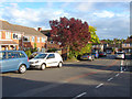
Anchor Hill, Knaphill
The shops in the first block on the right include Knaphill Cafe, which offers breakfast, lunch and dinner, and a firm of funeral directors. The road coming in from the left is Barnby Road.
Image: © P L Chadwick
Taken: 20 Jun 2011
0.06 miles
7
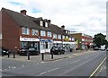
Shops in Anchor Hill, Knaphill
The shops and businesses include Roberts Care Agency, Iron Express (an ironing service), Cabaret Dancewear, a barbers, a Chinese takeaway and others.
Image: © P L Chadwick
Taken: 20 Jun 2011
0.06 miles
8
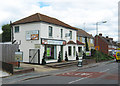
Optiplan, Coombe Villa, Anchor Hill, Knaphill
Optiplan provide bespoke kitchens. They were established in 1984, and have several branches. The Knaphill branch was opened in 2007. Prior to that, the premises were occupied by a firm called Millwood DIY.
Image: © P L Chadwick
Taken: 20 Jun 2011
0.06 miles
9
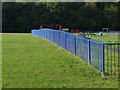
Blue fence, Waterer's Park
The fence around the children's play area in Waterer's Park with the edge of the small wooded area owned by the Woodland Trust in the background.
Image: © Alan Hunt
Taken: 1 Oct 2012
0.06 miles
10
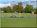
Waterer's Park, Knaphill
The children's play area in Waterer's Park with the football pitch in the background.
Image: © Alan Hunt
Taken: 1 Oct 2012
0.07 miles