IMAGES TAKEN NEAR TO
Lower Guildford Road, WOKING, GU21 2EN
Introduction
This page details the photographs taken nearby to Lower Guildford Road, GU21 2EN by members of the Geograph project.
The Geograph project started in 2005 with the aim of publishing, organising and preserving representative images for every square kilometre of Great Britain, Ireland and the Isle of Man.

There are currently over 7.5m images from over14,400 individuals and you can help contribute to the project by visiting https://www.geograph.org.uk
Image Map
Images are licensed for reuse under creativecommons.org/licenses/by-sa/2.0
Notes
- Clicking on the map will re-center to the selected point.
- The higher the marker number, the further away the image location is from the centre of the postcode.
Image Listing (38 Images Found)
Images are licensed for reuse under creativecommons.org/licenses/by-sa/2.0
Image
Details
Distance
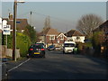
1
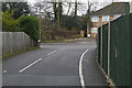
Wood Lane junction, Knaphill
The junction of Wood Lane with the Lower Guildford Road. Wood Lane is a short residential road between Victoria Road and the Lower Guildford Road.
Image: © Alan Hunt
Taken: 1 Feb 2016
0.05 miles
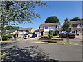
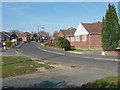
2
Clinton Close, Knaphill
Clinton Close from the junction with Burnham Road.
Image: © Alan Hunt
Taken: 11 Mar 2015
0.08 miles
4
Wood Lane, Knaphill
Wood Lane viewed from Victoria Road.
Image: © Alan Hunt
Taken: 1 Feb 2016
0.10 miles
5
Wood Lane, Knaphill
A view along Wood Lane which runs from the Lower Guildford Road towards Victoria Road.
Image: © Alan Hunt
Taken: 14 Jan 2012
0.12 miles
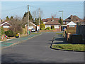
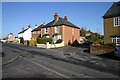
6
Burnham Road, Knaphill
A cul-de sac in the 1960s housing estate between Victoria Road and Lower Guildford Road.
Image: © Alan Hunt
Taken: 11 Mar 2015
0.12 miles
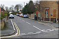
7
Junction of Queens Road and Englefield Road Knaphill
Junction of Queens Road and Englefield Road taken from entrance to Powderham Court. Illustrating typical house style from early 20th century.
Image: © Bill Ross
Taken: 10 Apr 2006
0.14 miles
8
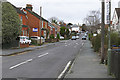
Victoria Road, Knaphill
Looking west along Victoria Road towards the village centre.
Image: © Alan Hunt
Taken: 1 Feb 2016
0.15 miles
9
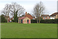
The Vyne playing fields, Knaphill
A toilet block in the northeast corner of the playing fields with Alexandra Gardens beyond.
Image: © Alan Hunt
Taken: 13 Jan 2016
0.15 miles
10
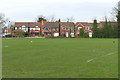
The Vyne playing fields, Knaphill
The playing fields with the houses along Alexandra gardens beyond.
Image: © Alan Hunt
Taken: 13 Jan 2016
0.17 miles