IMAGES TAKEN NEAR TO
Beechwood Road, WOKING, GU21 2DJ
Introduction
This page details the photographs taken nearby to Beechwood Road, GU21 2DJ by members of the Geograph project.
The Geograph project started in 2005 with the aim of publishing, organising and preserving representative images for every square kilometre of Great Britain, Ireland and the Isle of Man.

There are currently over 7.5m images from over14,400 individuals and you can help contribute to the project by visiting https://www.geograph.org.uk
Image Map
Images are licensed for reuse under creativecommons.org/licenses/by-sa/2.0
Notes
- Clicking on the map will re-center to the selected point.
- The higher the marker number, the further away the image location is from the centre of the postcode.
Image Listing (35 Images Found)
Images are licensed for reuse under creativecommons.org/licenses/by-sa/2.0
Image
Details
Distance
1
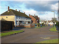
Nursery Road, Knaphill
Nursery Road in Lower Knaphill.
Image: © Alan Hunt
Taken: 5 Feb 2015
0.07 miles
2
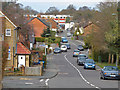
Lower Knaphill
A view along Robin Hood Road which becomes Barnby Road near the red brick gable. The parade of shops on Anchor Hill are in the far background.
Image: © Alan Hunt
Taken: 14 Apr 2013
0.08 miles
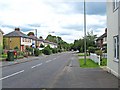
3
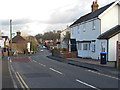
Barnby Road, Knaphill
Looking down Barnby Road from near the junction with Anchor Hill.
Image: © Alan Hunt
Taken: 5 Feb 2015
0.09 miles
4
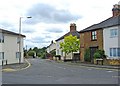
Junction of Barnby Road with Anchor Hill, Knaphill
The road in the immediate foreground is Anchor Hill.
Image: © P L Chadwick
Taken: 20 Jun 2011
0.13 miles
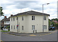
5
Barnby Road junction, Knaphill
The house at the junction of Barnby Road and Anchor Hill.
Image: © Alan Hunt
Taken: 5 Feb 2015
0.14 miles
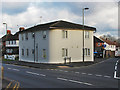
6
Chandler House, 1 Barnby Road, Knaphill
The building, on the corner of Barnby Road and Anchor Hill, is divided into flats.
Image: © P L Chadwick
Taken: 20 Jun 2011
0.14 miles
7
Semper Close, Knaphill
One of the side roads off Creston Avenue.
Image: © Alan Hunt
Taken: 14 Apr 2013
0.15 miles
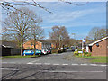
8
Anchor Hill, Knaphill
Behind the houses on the left is Waterers Park. At one time Knaphill Football Club played there, but they moved elsewhere a few years ago.
Image: © P L Chadwick
Taken: 20 Jun 2011
0.15 miles
9
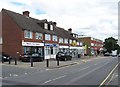
Shops in Anchor Hill, Knaphill
The shops and businesses include Roberts Care Agency, Iron Express (an ironing service), Cabaret Dancewear, a barbers, a Chinese takeaway and others.
Image: © P L Chadwick
Taken: 20 Jun 2011
0.16 miles
10
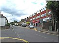
Anchor Hill, Knaphill
The shops in the first block on the right include Knaphill Cafe, which offers breakfast, lunch and dinner, and a firm of funeral directors. The road coming in from the left is Barnby Road.
Image: © P L Chadwick
Taken: 20 Jun 2011
0.16 miles