IMAGES TAKEN NEAR TO
Hatch End, WINDLESHAM, GU20 6QB
Introduction
This page details the photographs taken nearby to Hatch End, GU20 6QB by members of the Geograph project.
The Geograph project started in 2005 with the aim of publishing, organising and preserving representative images for every square kilometre of Great Britain, Ireland and the Isle of Man.

There are currently over 7.5m images from over14,400 individuals and you can help contribute to the project by visiting https://www.geograph.org.uk
Image Map
Images are licensed for reuse under creativecommons.org/licenses/by-sa/2.0
Notes
- Clicking on the map will re-center to the selected point.
- The higher the marker number, the further away the image location is from the centre of the postcode.
Image Listing (14 Images Found)
Images are licensed for reuse under creativecommons.org/licenses/by-sa/2.0
Image
Details
Distance
1
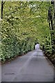
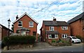
Windlesham - So Very Green
Westwood Road in Windlesam. Full of some very expensive properties and some very green trees
Image: © Colin Haywood-Gray
Taken: 8 May 2006
0.01 miles

4
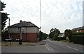
Windlesham
A substantial bus shelter, in keeping with its surroundings.
Image: © Peter Trimming
Taken: 19 May 2016
0.20 miles
5
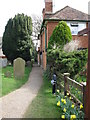
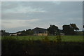
Footpath from the church
This path starts directly outside the south door of St John the Baptist parish church.
Image: © don cload
Taken: 26 Mar 2010
0.21 miles
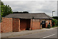
10
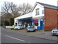
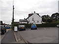
Chequers cars
The small garage on Updown Hill in Windlesham.
Image: © Alan Hunt
Taken: 20 Feb 2014
0.23 miles