IMAGES TAKEN NEAR TO
School Road, WINDLESHAM, GU20 6PB
Introduction
This page details the photographs taken nearby to School Road, GU20 6PB by members of the Geograph project.
The Geograph project started in 2005 with the aim of publishing, organising and preserving representative images for every square kilometre of Great Britain, Ireland and the Isle of Man.

There are currently over 7.5m images from over14,400 individuals and you can help contribute to the project by visiting https://www.geograph.org.uk
Image Map
Images are licensed for reuse under creativecommons.org/licenses/by-sa/2.0
Notes
- Clicking on the map will re-center to the selected point.
- The higher the marker number, the further away the image location is from the centre of the postcode.
Image Listing (19 Images Found)
Images are licensed for reuse under creativecommons.org/licenses/by-sa/2.0
Image
Details
Distance
1
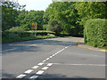
School Lane, Windlesham
The B386, School Lane from its junction with Snow Ride (on the right)
Image: © Alan Hunt
Taken: 30 Apr 2011
0.14 miles
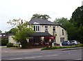
2
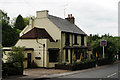
The Bee
Located on School Road, close to the junction with London Road (A30).
Image: © Peter Trimming
Taken: 19 May 2016
0.14 miles
4
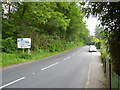
School Road, Windlesham
The B386 looking towards the junction with the A30.
Image: © Robin Webster
Taken: 4 Jun 2016
0.16 miles
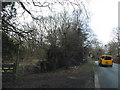
7
School Road at the junction of Snows Ride
Image: © David Howard
Taken: 1 Feb 2015
0.19 miles
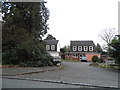
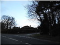
8
London Road at the junction of Sunninghill Road
Image: © David Howard
Taken: 18 Mar 2012
0.20 miles
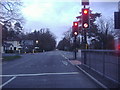
9
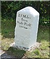
Old Milestone by the A30, London Road, Earl Wood Manor, north of Windlesham
Carved stone post by the A30, in parish of Windlesham (Surrey Heath District), Erl Wood Manor, opposite Windmill pub and junction with B3020, on grass verge behind footpath, on South south-east side of road. Re-used Hounslow limestone square, erected by the Egham & Bagshot Turnpike Trust in the 18th century.
Inscription reads:-
25 Miles
from
Hyde Park
corner
Carved benchmark on mid back.
Grade II Listed by Historic England, list entry number: 1474953 https://historicengland.org.uk/listing/the-list/list-entry/1474953
Milestone Society National ID: SY_LE25
Image: © Tim Dodds
Taken: 31 Aug 2017
0.20 miles
10
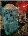
Old Milestone by the A30, London Road, Earl Wood Manor, north of Windlesham
Carved stone post by the A30, in parish of Windlesham (Surrey Heath District), Erl Wood Manor, opposite Windmill pub and junction with B3020, on grass verge behind footpath, on South south-east side of road. Re-used Hounslow limestone square, erected by the Egham & Bagshot Turnpike Trust in the 18th century.
Inscription reads:-
25 Miles
from
Hyde Park
corner
Carved benchmark on mid back.
Grade II Listed by Historic England, list entry number: 1474953 https://historicengland.org.uk/listing/the-list/list-entry/1474953
Milestone Society National ID: SY_LE25
Image: © Nathaniel Cleland
Taken: 22 Apr 2024
0.20 miles