IMAGES TAKEN NEAR TO
Chertsey Road, WINDLESHAM, GU20 6HY
Introduction
This page details the photographs taken nearby to Chertsey Road, GU20 6HY by members of the Geograph project.
The Geograph project started in 2005 with the aim of publishing, organising and preserving representative images for every square kilometre of Great Britain, Ireland and the Isle of Man.

There are currently over 7.5m images from over14,400 individuals and you can help contribute to the project by visiting https://www.geograph.org.uk
Image Map
Images are licensed for reuse under creativecommons.org/licenses/by-sa/2.0
Notes
- Clicking on the map will re-center to the selected point.
- The higher the marker number, the further away the image location is from the centre of the postcode.
Image Listing (15 Images Found)
Images are licensed for reuse under creativecommons.org/licenses/by-sa/2.0
Image
Details
Distance
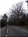
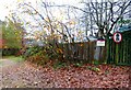
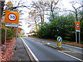
6
Looking east on Chertsey Road from numberless bridleway
Image: © Shazz
Taken: 27 Nov 2014
0.11 miles
7
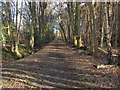
Footpath through the woods
The footpath that runs from the Chertsey Road, Windlesham towards Highams Lane, Valley End.
Image: © Alan Hunt
Taken: 22 Feb 2014
0.11 miles
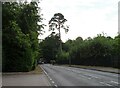
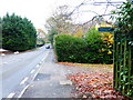
10
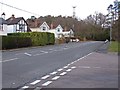
Chertsey Road, Windlesham
Looking east along Chertsey Road from the junction with Heathpark Drive.
Image: © Alan Hunt
Taken: 20 Feb 2014
0.19 miles