IMAGES TAKEN NEAR TO
Hutton Close, WINDLESHAM, GU20 6DN
Introduction
This page details the photographs taken nearby to Hutton Close, GU20 6DN by members of the Geograph project.
The Geograph project started in 2005 with the aim of publishing, organising and preserving representative images for every square kilometre of Great Britain, Ireland and the Isle of Man.

There are currently over 7.5m images from over14,400 individuals and you can help contribute to the project by visiting https://www.geograph.org.uk
Image Map
Images are licensed for reuse under creativecommons.org/licenses/by-sa/2.0
Notes
- Clicking on the map will re-center to the selected point.
- The higher the marker number, the further away the image location is from the centre of the postcode.
Image Listing (14 Images Found)
Images are licensed for reuse under creativecommons.org/licenses/by-sa/2.0
Image
Details
Distance

2
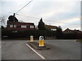
Updown Hill at the junction of Thorndown Lane
Image: © David Howard
Taken: 1 Feb 2015
0.14 miles
4
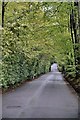
Windlesham - So Very Green
Westwood Road in Windlesam. Full of some very expensive properties and some very green trees
Image: © Colin Haywood-Gray
Taken: 8 May 2006
0.20 miles
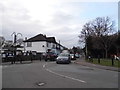
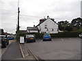
5
Windlesham Village
Looking along Chertsey Road from the junction with Updown Hill. The Sun public house is just across the junction.
Image: © Alan Hunt
Taken: 20 Feb 2014
0.20 miles
7
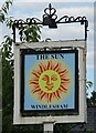
Sign for the Sun, Windlesham
See Image] for context.
Image: © JThomas
Taken: 29 Jul 2022
0.21 miles
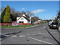
8
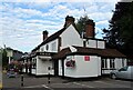
The Sun, Windlesham
On Chertsey Road.
See Image] for context.
Image: © JThomas
Taken: 29 Jul 2022
0.22 miles
10
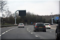
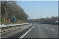
Surrey Heath : M3 Motorway
The M3 Motorway between Junction 2 (Thorpe Interchange) and Junction 3 (Bagshot Interchange).
Image: © Lewis Clarke
Taken: 25 Mar 2018
0.22 miles