IMAGES TAKEN NEAR TO
Bagshot Park, BAGSHOT, GU19 5PJ
Introduction
This page details the photographs taken nearby to Bagshot Park, GU19 5PJ by members of the Geograph project.
The Geograph project started in 2005 with the aim of publishing, organising and preserving representative images for every square kilometre of Great Britain, Ireland and the Isle of Man.

There are currently over 7.5m images from over14,400 individuals and you can help contribute to the project by visiting https://www.geograph.org.uk
Image Map
Images are licensed for reuse under creativecommons.org/licenses/by-sa/2.0
Notes
- Clicking on the map will re-center to the selected point.
- The higher the marker number, the further away the image location is from the centre of the postcode.
Image Listing (10 Images Found)
Images are licensed for reuse under creativecommons.org/licenses/by-sa/2.0
Image
Details
Distance
1
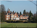
Bagshot Park House
Bagshot Park House as seen from the Parish Church of St Anne. The house is currently the residence of Prince Edward, the Earl of Wessex.
Image: © Len Williams
Taken: 25 Nov 2012
0.01 miles
2
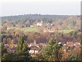
Bagshot Park
Bagshot Park as seen from the summit of White Hill.
Image: © Len Williams
Taken: 19 Nov 2008
0.01 miles
4

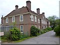
Bagshot Park and Farm
There has been a Royal hunting lodge on the site now known as Bagshot Park for many centuries: it was well favoured by the Stuart kings. Later it was used by various officers of the Royal household. In 1875 Queen Victoria had a new house built on the estate for her third son, Prince Arthur, Duke of Connaught upon his marriage. The original building being demolished in 1878. The Duke lived there on-and-off until his death in 1942. For about 50 years following the end of the Second World War the buildings were used as the centre for the Royal Army Chaplains' Department. Bagshot Park is now once again a Royal residence. It is the home of Their Royal Highnesses the Earl and Countess of Wessex (Prince Edward and Sophie).
Image: © Roger
Taken: 27 Sep 2008
0.04 miles
5

High Curley hill view
This is the view from the summit of High Curley hill. Refer to picture Image for the start of the walk from The Maultway to the summit of the hill.
Image: © Len Williams
Taken: 6 Aug 2014
0.14 miles
6
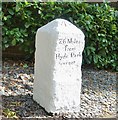
Old Milestone by the A30, London Road, Bagshot Park
Carved stone post by the A30, in parish of Windlesham (Surrey Heath District), Bagshot Park, by No. 24 London Road, in border between brick wall and footpath, on East South-east side of road. Re-used Hounslow limestone square, erected by the Egham & Bagshot Turnpike Trust in the 18th century.
Inscription reads:-
26 Miles
from
Hyde Park
corner
Carved benchmark and rivet on top.
Grade II Listed by Historic England, list entry number: 1474955 https://historicengland.org.uk/listing/the-list/list-entry/1474955
Milestone Society National ID: SY_LE26
Image: © Tim Dodds
Taken: 1 Sep 2017
0.22 miles
7
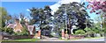
Bagshot Park Entrance Gate
The original entrance to Bagshot Park from the A30 complete with gatehouse. This has now been superseded by a different entrance further up the A30 near the Cricketers Restaurant.
Image: © Len Williams
Taken: 28 Apr 2015
0.24 miles
8
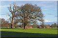
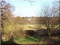
Bagshot Park
The farmland around Bagshot Park with the buildings of Home Farm beyond.
Image: © Alan Hunt
Taken: 4 Mar 2016
0.24 miles
9
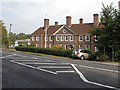
The Archaeology Centre, Bagshot
The Surrey Heath Archaeology Centre on the A30, London Road on the edge of Bagshot village. This building used to be Bagshot Police station until it was converted to a centre for storing and documenting archaeological finds from across Surrey Heath.
Image: © Alan Hunt
Taken: 23 Sep 2014
0.25 miles