IMAGES TAKEN NEAR TO
Manor Way, BAGSHOT, GU19 5JY
Introduction
This page details the photographs taken nearby to Manor Way, GU19 5JY by members of the Geograph project.
The Geograph project started in 2005 with the aim of publishing, organising and preserving representative images for every square kilometre of Great Britain, Ireland and the Isle of Man.

There are currently over 7.5m images from over14,400 individuals and you can help contribute to the project by visiting https://www.geograph.org.uk
Image Map
Images are licensed for reuse under creativecommons.org/licenses/by-sa/2.0
Notes
- Clicking on the map will re-center to the selected point.
- The higher the marker number, the further away the image location is from the centre of the postcode.
Image Listing (30 Images Found)
Images are licensed for reuse under creativecommons.org/licenses/by-sa/2.0
Image
Details
Distance
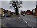
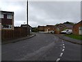
1
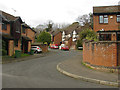
Drayhorse Crescent, Bagshot
One of the side roads of Drayhorse Crescent in the Connaught Park area of Bagshot.
Image: © Alan Hunt
Taken: 11 Dec 2014
0.10 miles
2
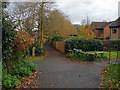
Walkway, Bagshot
A walkway through the Connaught Park housing estates to the south of the railway line.
Image: © Alan Hunt
Taken: 11 Dec 2014
0.11 miles
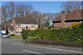
3
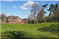
Former pond off Whitmoor Road, Bagshot
This dip in the ground south of Whitmore Road was a former pond in the grounds of Failthe (later Weston) House, the only property in the area now occupied by the Connaught Park estate and the M3 motorway. The house dating from about 1890 still stands off to the right.
Image: © Alan Hunt
Taken: 7 Mar 2016
0.11 miles
4
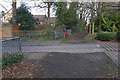
Footpath, Connaught Estate, Bagshot
The footpath crossing the end of Whitmoor Road in the Connaught Estate south of Bagshot Village.
Image: © Alan Hunt
Taken: 7 Mar 2016
0.11 miles
5
Green Lane
Looking along Green Lane, past a junction to Broomsquires Road. Green Lane connects to Badger Swift Way and Whitmoor Road, near the A322.
Image: © Oscar Taylor
Taken: 1 Apr 2023
0.12 miles
6
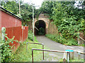
Railway bridge AAV 24/8
A public footpath passes under the Ascot Junction to Ash Vale Junction line.
Image: © Robin Webster
Taken: 27 Aug 2015
0.12 miles
7
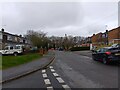
Broomsquires Road
Broomsquires Road is a road between Elizabeth Avenue and Green Lane. It connects to Green Lane in two places.
Image: © Oscar Taylor
Taken: 1 Apr 2023
0.13 miles
8
Connaught Park, Bagshot
Horsebrass drive in the Connaught Park estate to the south of Bagshot village.
Image: © Alan Hunt
Taken: 7 Mar 2016
0.13 miles
9
Broomsquires Road
Broomsquires Road is a road between Elizabeth Avenue and Green Lane. It connects to Green Lane in two places.
Image: © Oscar Taylor
Taken: 1 Apr 2023
0.13 miles
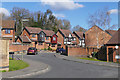
10
Kemp Court, Bagshot
Kemp court off Whitmoor Road in the Connaught Park estate built during the 1980's.
Image: © Alan Hunt
Taken: 7 Mar 2016
0.14 miles