IMAGES TAKEN NEAR TO
Chapel Lane, BAGSHOT, GU19 5BX
Introduction
This page details the photographs taken nearby to Chapel Lane, GU19 5BX by members of the Geograph project.
The Geograph project started in 2005 with the aim of publishing, organising and preserving representative images for every square kilometre of Great Britain, Ireland and the Isle of Man.

There are currently over 7.5m images from over14,400 individuals and you can help contribute to the project by visiting https://www.geograph.org.uk
Image Map
Images are licensed for reuse under creativecommons.org/licenses/by-sa/2.0
Notes
- Clicking on the map will re-center to the selected point.
- The higher the marker number, the further away the image location is from the centre of the postcode.
Image Listing (52 Images Found)
Images are licensed for reuse under creativecommons.org/licenses/by-sa/2.0
Image
Details
Distance
1
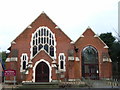
Bagshot Methodist Church
Situated in a less than peaceful location next to the A30.
Image: © Andrew Smith
Taken: 18 Feb 2006
0.02 miles
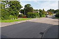
2
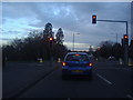
Junction of London Road and Yaverland Road
Image: © David Howard
Taken: 18 Mar 2012
0.04 miles
3
Navigating northwards up the Basher (29)
Looking from Yaverland Drive into Lower Mill Field
Image: © Basher Eyre
Taken: 5 Jun 2023
0.07 miles
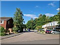
4
Mill Field, Bagshot
The junction between Mill Field and Higgs Lane on the right.
Image: © Alan Hunt
Taken: 11 Sep 2015
0.08 miles
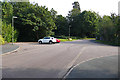
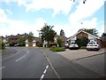
5
Yaverland Drive, Bagshot
The junction between Yaverland Drive and Higgs Lane.
Image: © Alan Hunt
Taken: 11 Sep 2015
0.09 miles
7
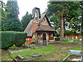
Cemetery chapel, Bagshot
A small graveyard off School Lane.
Image: © Robin Webster
Taken: 27 Aug 2015
0.10 miles
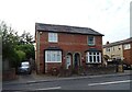
9
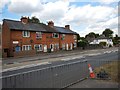
Bagshot - Terrace Cottages on the London Road
Image: © James Emmans
Taken: 9 Jul 2017
0.13 miles
10
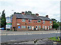
Myrtle Cottages, Bagshot
49 to 57 (odds) London Road, the A30.
Image: © Robin Webster
Taken: 27 Aug 2015
0.14 miles