IMAGES TAKEN NEAR TO
High View Road, LIGHTWATER, GU18 5YE
Introduction
This page details the photographs taken nearby to High View Road, GU18 5YE by members of the Geograph project.
The Geograph project started in 2005 with the aim of publishing, organising and preserving representative images for every square kilometre of Great Britain, Ireland and the Isle of Man.

There are currently over 7.5m images from over14,400 individuals and you can help contribute to the project by visiting https://www.geograph.org.uk
Image Map
Images are licensed for reuse under creativecommons.org/licenses/by-sa/2.0
Notes
- Clicking on the map will re-center to the selected point.
- The higher the marker number, the further away the image location is from the centre of the postcode.
Image Listing (6 Images Found)
Images are licensed for reuse under creativecommons.org/licenses/by-sa/2.0
Image
Details
Distance
1
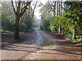
Curley Hill Road
The access road off Macdonald Road that also serves as a byway leading to High Curley.
Image: © Alan Hunt
Taken: 20 Jan 2014
0.10 miles
2
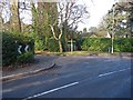
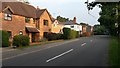
Macdonald Road
Macdonald Road looking towards the junction with Curley Hill Road on the left.
Image: © Alan Hunt
Taken: 20 Jan 2014
0.10 miles
3
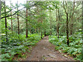
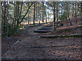
Path, Bagshot Heath
Leading to High View Road.
Image: © Robin Webster
Taken: 27 Aug 2015
0.11 miles
4
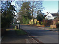
Ambleside Road, Lightwater
The western end of this long straight road that runs from the village centre westward to Macdonald Road, a distance of 1.4km.
Image: © Alan Hunt
Taken: 20 Jan 2014
0.14 miles
6
Stepped path
The stepped path to the top of High Curley, part of the Lightwater Country Park.
Image: © Alan Hunt
Taken: 20 Jan 2014
0.24 miles