IMAGES TAKEN NEAR TO
Minley Manor, CAMBERLEY, GU17 9JT
Introduction
This page details the photographs taken nearby to Minley Manor, GU17 9JT by members of the Geograph project.
The Geograph project started in 2005 with the aim of publishing, organising and preserving representative images for every square kilometre of Great Britain, Ireland and the Isle of Man.

There are currently over 7.5m images from over14,400 individuals and you can help contribute to the project by visiting https://www.geograph.org.uk
Image Map (Loading...)


Getting Data...Please wait
Leaflet Map data © OpenStreetMap
Images are licensed for reuse under creativecommons.org/licenses/by-sa/2.0
Notes
- Clicking on the map will re-center to the selected point.
- The higher the marker number, the further away the image location is from the centre of the postcode.
Image Listing (4 Images Found)
Images are licensed for reuse under creativecommons.org/licenses/by-sa/2.0
Image
Details
Distance
1
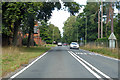
A327 Minley Road
Gibraltar Barracks is behind the fence on the right, on the left is the main entrance and lodge to Minley Manor.
Image: © Robin Webster
Taken: 22 Aug 2020
0.05 miles
2

Minley Manor
An MOD listed country manor house currently used as a Royal Engineer officers' mess.
Image: © Diane Sambrook
Taken: 9 Apr 2008
0.13 miles
3

St. Andrew, Minley
Military church in the grounds of Minley Manor. Built in 1871.
Image: © Michael FORD
Taken: Unknown
0.14 miles
4
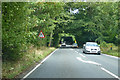
A327 Minley Road
Towards Minley and the A30.
Image: © Robin Webster
Taken: 22 Aug 2020
0.20 miles