IMAGES TAKEN NEAR TO
Clarendon Court, CAMBERLEY, GU17 9JN
Introduction
This page details the photographs taken nearby to Clarendon Court, GU17 9JN by members of the Geograph project.
The Geograph project started in 2005 with the aim of publishing, organising and preserving representative images for every square kilometre of Great Britain, Ireland and the Isle of Man.

There are currently over 7.5m images from over14,400 individuals and you can help contribute to the project by visiting https://www.geograph.org.uk
Image Map (Loading...)


Getting Data...Please wait
Leaflet Map data © OpenStreetMap
Images are licensed for reuse under creativecommons.org/licenses/by-sa/2.0
Notes
- Clicking on the map will re-center to the selected point.
- The higher the marker number, the further away the image location is from the centre of the postcode.
Image Listing (27 Images Found)
Images are licensed for reuse under creativecommons.org/licenses/by-sa/2.0
Image
Details
Distance
3
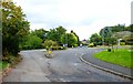
Woodside, Blackwater
A public bridleway and a road leading to Hawley Common and some houses.
Image: © Oscar Taylor
Taken: 22 Jun 2024
0.07 miles
4
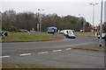
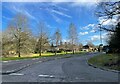
Blackwater
The major roundabout, almost mid-square, looking east-northeast towards Blackwater and Camberley.
Image: © Brendan and Ruth McCartney
Taken: Unknown
0.08 miles
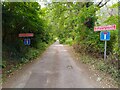
6
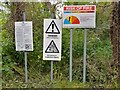
A lot to read
Signs on signs at Hawley Common.
Image: © Oscar Taylor
Taken: 22 Jun 2024
0.09 miles
9
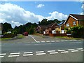
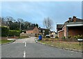
Springcross Avenue
B3272 (Hawley Road) is in the foreground.
Image: © Shazz
Taken: 20 Jun 2012
0.10 miles