IMAGES TAKEN NEAR TO
Fernhill Road, CAMBERLEY, GU17 9HS
Introduction
This page details the photographs taken nearby to Fernhill Road, GU17 9HS by members of the Geograph project.
The Geograph project started in 2005 with the aim of publishing, organising and preserving representative images for every square kilometre of Great Britain, Ireland and the Isle of Man.

There are currently over 7.5m images from over14,400 individuals and you can help contribute to the project by visiting https://www.geograph.org.uk
Image Map
Images are licensed for reuse under creativecommons.org/licenses/by-sa/2.0
Notes
- Clicking on the map will re-center to the selected point.
- The higher the marker number, the further away the image location is from the centre of the postcode.
Image Listing (143 Images Found)
Images are licensed for reuse under creativecommons.org/licenses/by-sa/2.0
Image
Details
Distance
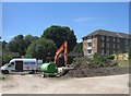
3
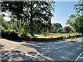
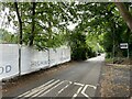
Demolition site - Fernhill Road
This is where Randell House once stood.
Image: © Fernweh
Taken: 20 Jul 2021
0.03 miles
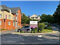
6
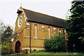
All Saints Old Church, Hawley
Built in 1881 and is now in the grounds of Randell House.
Image: © Michael FORD
Taken: Unknown
0.05 miles
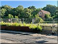
8
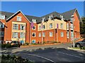
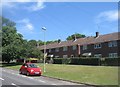
Gracewell of Camberley - Fernhill Road
A lot has changed in 7 years, Image
Image: © Fernweh
Taken: 20 Jul 2021
0.05 miles