IMAGES TAKEN NEAR TO
Oakfield Road, CAMBERLEY, GU17 9DZ
Introduction
This page details the photographs taken nearby to Oakfield Road, GU17 9DZ by members of the Geograph project.
The Geograph project started in 2005 with the aim of publishing, organising and preserving representative images for every square kilometre of Great Britain, Ireland and the Isle of Man.

There are currently over 7.5m images from over14,400 individuals and you can help contribute to the project by visiting https://www.geograph.org.uk
Image Map (Loading...)


Getting Data...Please wait
Leaflet Map data © OpenStreetMap
Images are licensed for reuse under creativecommons.org/licenses/by-sa/2.0
Notes
- Clicking on the map will re-center to the selected point.
- The higher the marker number, the further away the image location is from the centre of the postcode.
Image Listing (93 Images Found)
Images are licensed for reuse under creativecommons.org/licenses/by-sa/2.0
Image
Details
Distance
2
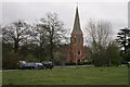
Hawley
Holy Trinity Church on the B3272 north of Hawley.
Image: © Brendan and Ruth McCartney
Taken: 16 Apr 2005
0.02 miles
6
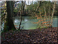
Pond by the River Blackwater
A small pond beside the River Blackwater with the houses of Blackwater through the treesbehind.
Image: © Alan Hunt
Taken: 28 Jan 2014
0.05 miles
8
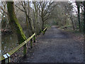
Blackwater Valley Path
The long distance path that follows the course of the River Blackwater.
Image: © Alan Hunt
Taken: 28 Jan 2014
0.06 miles