IMAGES TAKEN NEAR TO
The Glebe, CAMBERLEY, GU17 9BB
Introduction
This page details the photographs taken nearby to The Glebe, GU17 9BB by members of the Geograph project.
The Geograph project started in 2005 with the aim of publishing, organising and preserving representative images for every square kilometre of Great Britain, Ireland and the Isle of Man.

There are currently over 7.5m images from over14,400 individuals and you can help contribute to the project by visiting https://www.geograph.org.uk
Image Map (Loading...)


Getting Data...Please wait
Leaflet Map data © OpenStreetMap
Images are licensed for reuse under creativecommons.org/licenses/by-sa/2.0
Notes
- Clicking on the map will re-center to the selected point.
- The higher the marker number, the further away the image location is from the centre of the postcode.
Image Listing (83 Images Found)
Images are licensed for reuse under creativecommons.org/licenses/by-sa/2.0
Image
Details
Distance
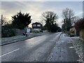
6
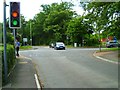
Crossroads in Hawley
The camera is looking north on Fernhill Road. The crossing road is the B3272 (Hawley Road).
Image: © Shazz
Taken: 20 Jun 2012
0.11 miles
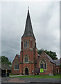
7
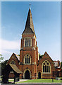
Holy Trinity, Hawley
Grade 2 listed building erected in 1857 on the outskirts of Blackwater.
Image: © Michael FORD
Taken: Unknown
0.11 miles
8
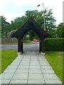
The arch at Hawley church
There are gates within the arch but they are open.
Image: © Shazz
Taken: 20 Jun 2012
0.11 miles
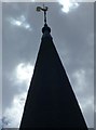
10
Holy Trinity, Hawley
Accretive, to use Pevsner's word. By J.B. Clacy, 1856-57, then Charles Buckeridge, 1867-68, and Arnold Hoole, 1907-08. The identity of the architect of the most prominent feature - the tower, added in 1882-83 - appears uncertain, possibly a bit of Buckeridge and a bit of Hoole. Grade II listed.
Image: © Stephen Richards
Taken: 9 Jul 2012
0.12 miles