IMAGES TAKEN NEAR TO
Beaulieu Gardens, CAMBERLEY, GU17 0LQ
Introduction
This page details the photographs taken nearby to Beaulieu Gardens, GU17 0LQ by members of the Geograph project.
The Geograph project started in 2005 with the aim of publishing, organising and preserving representative images for every square kilometre of Great Britain, Ireland and the Isle of Man.

There are currently over 7.5m images from over14,400 individuals and you can help contribute to the project by visiting https://www.geograph.org.uk
Image Map
Images are licensed for reuse under creativecommons.org/licenses/by-sa/2.0
Notes
- Clicking on the map will re-center to the selected point.
- The higher the marker number, the further away the image location is from the centre of the postcode.
Image Listing (10 Images Found)
Images are licensed for reuse under creativecommons.org/licenses/by-sa/2.0
Image
Details
Distance
1
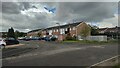
Selborne Close
A short cal-de-sac of terrace housing
Image: © James Emmans
Taken: 26 May 2021
0.13 miles
2
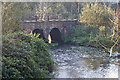
Blackwater River, Sandhurst
The Blackwater River passing under the Guildford to Reading railway line between Sandhurst and Yateley.
Image: © Anonymous 4452
Taken: 20 Nov 2005
0.17 miles
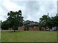
4
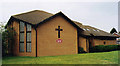
St. Barnabas, Darby Green
Modern brick built church.
Image: © Michael FORD
Taken: Unknown
0.19 miles
5
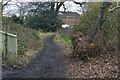
Path to Lyndhurst Avenue, Blackwater
The path from the River Blackwater to Lyndhurst Avenue in Blackwater village.
Image: © Alan Hunt
Taken: 25 Feb 2016
0.20 miles
6
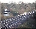
The Blackwater to Sandhurst railway line crossing the River Blackwater
Taken from the footbridge that goes from Shepherds Meadows Nature Reserve to Blackwater housing estates.
Image: © Diane Sambrook
Taken: 16 Jan 2008
0.22 miles
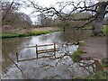
7
Stream into Blackwater River
A stream feeding the Blackwater River at Shepherd Meadows. Normally the stream is no more than a ditch, but with the heavy rain this week it is very high and wide. It was back-flowing from the river, rather than the opposite.
Image: © Oscar Taylor
Taken: 1 Apr 2023
0.24 miles
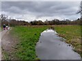
8
High water on Blackwater River
After a week of heavy rain, Blackwater River is very high in its banks at Shepherd Meadows.
Image: © Oscar Taylor
Taken: 1 Apr 2023
0.24 miles
9
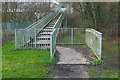
Railway footbridge, Shepherd Meadows
The footbridge carrying the Blackwater Valley Path over the railway line in the Shepherd Meadows countryside park.
Image: © Alan Hunt
Taken: 25 Feb 2016
0.25 miles
10
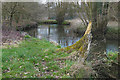
The Blackwater River
The Blackwater River flowing through the Shepherd Meadows wildlife reserve near Blackwater village.
Image: © Alan Hunt
Taken: 25 Feb 2016
0.25 miles