IMAGES TAKEN NEAR TO
East Green, CAMBERLEY, GU17 0AU
Introduction
This page details the photographs taken nearby to East Green, GU17 0AU by members of the Geograph project.
The Geograph project started in 2005 with the aim of publishing, organising and preserving representative images for every square kilometre of Great Britain, Ireland and the Isle of Man.

There are currently over 7.5m images from over14,400 individuals and you can help contribute to the project by visiting https://www.geograph.org.uk
Image Map
Images are licensed for reuse under creativecommons.org/licenses/by-sa/2.0
Notes
- Clicking on the map will re-center to the selected point.
- The higher the marker number, the further away the image location is from the centre of the postcode.
Image Listing (19 Images Found)
Images are licensed for reuse under creativecommons.org/licenses/by-sa/2.0
Image
Details
Distance

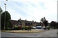
4
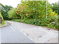
Junction of Reading and Frogmore Roads
The camera is in Lowlands Road.
Image: © Shazz
Taken: 1 Oct 2014
0.10 miles
5
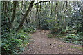
Path in woods on the edge of Blackwater
Image: © David Martin
Taken: 9 Oct 2014
0.11 miles
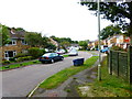
6
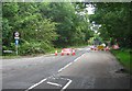
Road Closed
Reading Road, Yateley Common.
Image: © Mr Ignavy
Taken: 19 Aug 2011
0.14 miles
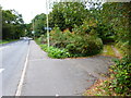
7
Looking east to the end of The Flats
The camera is in Lowlands Road.
Image: © Shazz
Taken: 1 Oct 2014
0.15 miles
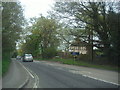
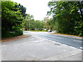
9
Looking westwards on the B3272 from junction with track
Image: © Shazz
Taken: 1 Oct 2014
0.18 miles
10
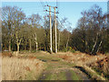
Electricity pylon, Yateley Common
One of the wooden electricity pylons from the line that runs across the common south of the A30.
Image: © Alan Hunt
Taken: 19 Dec 2014
0.18 miles