IMAGES TAKEN NEAR TO
Sandringham Way, CAMBERLEY, GU16 9XY
Introduction
This page details the photographs taken nearby to Sandringham Way, GU16 9XY by members of the Geograph project.
The Geograph project started in 2005 with the aim of publishing, organising and preserving representative images for every square kilometre of Great Britain, Ireland and the Isle of Man.

There are currently over 7.5m images from over14,400 individuals and you can help contribute to the project by visiting https://www.geograph.org.uk
Image Map (Loading...)


Getting Data...Please wait
Leaflet Map data © OpenStreetMap
Images are licensed for reuse under creativecommons.org/licenses/by-sa/2.0
Notes
- Clicking on the map will re-center to the selected point.
- The higher the marker number, the further away the image location is from the centre of the postcode.
Image Listing (21 Images Found)
Images are licensed for reuse under creativecommons.org/licenses/by-sa/2.0
Image
Details
Distance
1
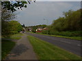
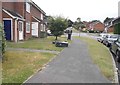
Balmoral Drive, Frimley
Balmoral Drive looking towards the housing developments on Burrow Hill.
Image: © Alan Hunt
Taken: 17 Apr 2011
0.06 miles
3
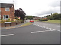
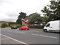
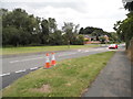
Buckingham Way at the junction of Balmoral Drive
Image: © David Howard
Taken: 27 Jul 2015
0.09 miles
4
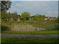
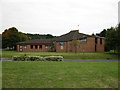
Burrow Hill, Frimley
The houses on Burrow Hill looking across the pond at the end of the recreation area that runs along Balmoral Drive.
Image: © Alan Hunt
Taken: 17 Apr 2011
0.09 miles