IMAGES TAKEN NEAR TO
Partridge Close, CAMBERLEY, GU16 8PD
Introduction
This page details the photographs taken nearby to Partridge Close, GU16 8PD by members of the Geograph project.
The Geograph project started in 2005 with the aim of publishing, organising and preserving representative images for every square kilometre of Great Britain, Ireland and the Isle of Man.

There are currently over 7.5m images from over14,400 individuals and you can help contribute to the project by visiting https://www.geograph.org.uk
Image Map (Loading...)


Getting Data...Please wait
Leaflet Map data © OpenStreetMap
Images are licensed for reuse under creativecommons.org/licenses/by-sa/2.0
Notes
- Clicking on the map will re-center to the selected point.
- The higher the marker number, the further away the image location is from the centre of the postcode.
Image Listing (44 Images Found)
Images are licensed for reuse under creativecommons.org/licenses/by-sa/2.0
Image
Details
Distance
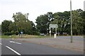
1
Portsmouth Road, Frimley
At the junction of Chobham Road
Image: © David Howard
Taken: 7 Jun 2015
0.05 miles
2

View across the green in front of Frimley Park Hospital
Image: © David Martin
Taken: 6 Sep 2014
0.06 miles
3
Office blocks near Frimley
The site of these blocks was owned by a large British Company. They moved into nearby premises and sold the land for development. Later they sold those premises and now rent a nice new block.
Image: © Graham Clutton
Taken: 3 Jan 2006
0.06 miles
4
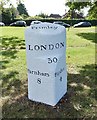
Old Milestone by the A325, Portsmouth Road, opposite Frimley Park Hospital
Carved stone post by the A325, in parish of Camberley (Surrey Heath District), Portsmouth Road near junction with Grove Cross Road; opposite grounds near Frimley Park Hospital, on open grass verge, on South-east side of road. Bagshot facet, erected by the Winchester, Upper District (Bagshot to Farnham) Turnpike Trust in the 18th century.
Inscription reads:-
: Farnham / 8 : : Frimley / LONDON / 30 : : Bagshot / 4 : : WINTON ³4 :
Carved benchmark back left.
Milestone Society National ID: SY_LWW30.
Image: © Milestone Society
Taken: 15 Sep 2017
0.07 miles
5
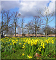
The Grove, Frimley, looking towards Frimley Park Hospital
The Grove in Frimley is an open area of grass and trees just south of the A325 road. The red-brown building which can be seen on the other side of the road is the car park for Frimley Park Hospital, and the Hospital buildings can just be seen beyond it.
This area of dwarf daffodils made a lively splash of colour in the February sunshine.
Image: © Euchiasmus
Taken: 26 Feb 2008
0.07 miles
6
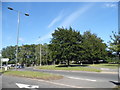
Roundabout on Portsmouth Road, Frimley
Image: © David Howard
Taken: 11 Sep 2022
0.08 miles
7

Field surrounded by trees
The grounds of Grove Primary school.
Image: © don cload
Taken: 18 May 2010
0.08 miles
8

The Old Village Pound
The Old Village Pound is an enclosed area in the village that served to hold stray animals.
Image: © don cload
Taken: 21 Jul 2009
0.09 miles
9
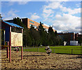
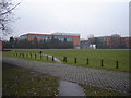
Playground, park and office building
An attractive park area south of the Chobham Road (B311) is bounded on the east side by the Head Office of Siemens Power Generation UK. This small children's playground at the northern end is often popular, but the low December sunshine was not enough to compensate for the strong cold wind when this photograph was taken.
Image: © Euchiasmus
Taken: 3 Dec 2007
0.10 miles
10

Frimley Grove Gardens, Frimley
Much of this area of Frimley was developed as a post war open estate, and this end of the road has mature detached houses set back from the street frontage. The location is within walking distance of Frimley shopping centre, Frimley Park Hospital and St. Peter's Church.
Image: © Euchiasmus
Taken: 15 May 2014
0.10 miles