IMAGES TAKEN NEAR TO
Ansell Road, CAMBERLEY, GU16 8BS
Introduction
This page details the photographs taken nearby to Ansell Road, GU16 8BS by members of the Geograph project.
The Geograph project started in 2005 with the aim of publishing, organising and preserving representative images for every square kilometre of Great Britain, Ireland and the Isle of Man.

There are currently over 7.5m images from over14,400 individuals and you can help contribute to the project by visiting https://www.geograph.org.uk
Image Map (Loading...)


Getting Data...Please wait
Leaflet Map data © OpenStreetMap
Images are licensed for reuse under creativecommons.org/licenses/by-sa/2.0
Notes
- Clicking on the map will re-center to the selected point.
- The higher the marker number, the further away the image location is from the centre of the postcode.
Image Listing (40 Images Found)
Images are licensed for reuse under creativecommons.org/licenses/by-sa/2.0
Image
Details
Distance
1
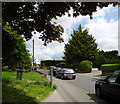
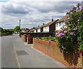
Junction of Ansell Road and Barnes Road, Frimley
Quiet roads in this residential area in the suburbs of Frimley.
Image: © Euchiasmus
Taken: 15 May 2014
0.02 miles
2
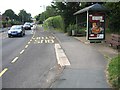
Ansell Road, Frimley
Ansell Road is a residential road leading east from the B3411 (Frimley Green Road). A little further up the road there is a convenience store and a pet shop.
Image: © Euchiasmus
Taken: 15 May 2014
0.06 miles
4
Top of Ansell Road, Frimley
Ansell Road is a mature residential area to the east of Frimley town centre, with houses built over fifty years ago. Towards the bottom of the road there is a convenience store and a pet shop. This photograph is taken from the highest point on Ansell Road; beyond here the road bends to the north and becomes Bret Harte Road, which goes steeply downhill.
Image: © Euchiasmus
Taken: 15 May 2014
0.11 miles
5
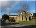
St Peter's church hall
The church hall on Parsonage Way with St Peter's Church in the background.
Image: © Alan Hunt
Taken: 7 Feb 2014
0.11 miles
6
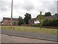
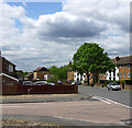
Green on Barnes Road
Compare with this larger version in Edgware, the houses and road design appear to come from the same plans.
http://www.geograph.org.uk/photo/4538706
Image: © David Howard
Taken: 27 Jul 2015
0.12 miles
8
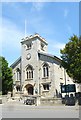
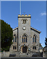
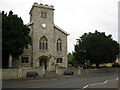
St Peter's Church, Frimley
Grade II listed building, built to the designs of architect J.T.Parkinson in 1825, with later alterations. Architectural description at this http://list.historicengland.org.uk/resultsingle.aspx?uid=1180188.
Image: © Jim Osley
Taken: 18 Jun 2015
0.13 miles
9
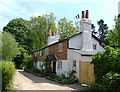
The Old Cottage, 8, Field Lane, Frimley
Field Lane is an unadopted road running along the north side of St Peter’s Church, adjacent to the churchyard. The Old Cottage on Field Lane is listed as a beerhouse in the 1841 census and used to be a small inn called the Queen's Head, nicknamed the Drum and Monkey because of its weathervane, visible on the chimney stack. Its location is close to the side gate into the graveyard and in the past it must have been convenient to have refreshment available for mourners attending a burial.
Image: © Euchiasmus
Taken: 19 May 2014
0.13 miles