IMAGES TAKEN NEAR TO
Sheridan Road, CAMBERLEY, GU16 7EG
Introduction
This page details the photographs taken nearby to Sheridan Road, GU16 7EG by members of the Geograph project.
The Geograph project started in 2005 with the aim of publishing, organising and preserving representative images for every square kilometre of Great Britain, Ireland and the Isle of Man.

There are currently over 7.5m images from over14,400 individuals and you can help contribute to the project by visiting https://www.geograph.org.uk
Image Map (Loading...)


Getting Data...Please wait
Leaflet Map data © OpenStreetMap
Images are licensed for reuse under creativecommons.org/licenses/by-sa/2.0
Notes
- Clicking on the map will re-center to the selected point.
- The higher the marker number, the further away the image location is from the centre of the postcode.
Image Listing (96 Images Found)
Images are licensed for reuse under creativecommons.org/licenses/by-sa/2.0
Image
Details
Distance
1
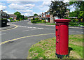
Sheridan Road, Frimley
Sheridan Road is a quiet residential road within walking distance of Frimley shopping centre.
Image: © Euchiasmus
Taken: 14 May 2014
0.01 miles
2
Burleigh Road, Frimley
Burleigh Road is a quiet residential road within walking distance of Frimley shopping centre.
Image: © Euchiasmus
Taken: 14 May 2014
0.05 miles
3
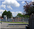
Electricity sub-station and public car park, Frimley
This electricity sub-station is located adjacent to a public pay-and-display car park just behind a parade of shops on Frimley High Street in the centre of Frimley. The sub-station is bounded on the far side by residential properties on Burleigh Road; one of these, Whitebourne Care Home, can be seen on the left of the photograph. The fence on the right of the photograph bounds the back gardens of houses in Leonard Close.
Image: © Euchiasmus
Taken: 19 May 2014
0.09 miles
4
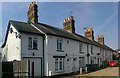
Cottages in Cedar Lane
Cedar Lane is in the heart of Frimley but is un-metalled. These cottages appear to date from a bygone era, although they have been tastefully renovated.
Image: © Len Williams
Taken: 23 Mar 2012
0.09 miles
5
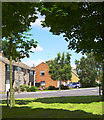
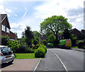
Houses in Sheridan Road
This photograph is taken from a pleasant green open space between Sheridan Road and Hollytree Gardens in this quiet residential area just south of the centre of Frimley.
Image: © Euchiasmus
Taken: 30 Jul 2007
0.09 miles
6
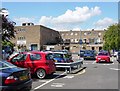
The "rear of the parade car park"
This large car park is very convenient for Frimley town centre: the building in view is the back of the shops along Frimley's main shopping street. A few trees provide limited shade, and a yellow "height limit" bar can be seen at the entrance/exit in the distance on the left.
Image: © Euchiasmus
Taken: 7 Aug 2007
0.10 miles
7
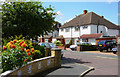
Hollytree Gardens leading to Sheridan Road
This residential area south of Frimley High Street is pleasant, well-spaced and quiet, with green space and trees. All the amenities of Frimley town centre are within walking distance.
Image: © Euchiasmus
Taken: 30 Jul 2007
0.11 miles
8
Maybury Close
Maybury Close is a cul-de-sac running parallel to and south of Frimley High Street. The houses are within easy walking distance to the shopping centre and railway station.
Image: © Euchiasmus
Taken: 7 Aug 2007
0.12 miles
9
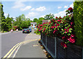
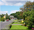
Burleigh Road, Frimley, looking north
Burleigh Road is a quiet residential road within easy walking distance to Frimley shopping centre, which is why parking is restricted by double yellow lines. This view looks north towards Church Road, the main B3411 leading into Frimley, which can just be seen at the T-junction at the end of the road, beyond the road works. Properties in the road have mature, attractive gardens.
Image: © Euchiasmus
Taken: 19 May 2014
0.12 miles
10

Frimley High Street
This photograph looks east along Frimley High Street, which is lined with shops on both sides. The Post Office is on the left, and there are several banks on the right. The White Hart pub can be seen (facing the camera) in the distance. The road leading off to the right in the foreground leads to Frimley railway station.
Image: © Euchiasmus
Taken: 9 Aug 2007
0.12 miles