IMAGES TAKEN NEAR TO
Cyprus Road, GU16 6TH
Introduction
This page details the photographs taken nearby to Cyprus Road, GU16 6TH by members of the Geograph project.
The Geograph project started in 2005 with the aim of publishing, organising and preserving representative images for every square kilometre of Great Britain, Ireland and the Isle of Man.

There are currently over 7.5m images from over14,400 individuals and you can help contribute to the project by visiting https://www.geograph.org.uk
Image Map (Loading...)


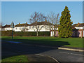
Getting Data...Please wait
Leaflet Map data © OpenStreetMap
Images are licensed for reuse under creativecommons.org/licenses/by-sa/2.0
Notes
- Clicking on the map will re-center to the selected point.
- The higher the marker number, the further away the image location is from the centre of the postcode.
Image Listing (14 Images Found)
Images are licensed for reuse under creativecommons.org/licenses/by-sa/2.0
Image
Details
Distance
1
Canada Road, Blackdown
Old army housing on Canada Road associated with the Alma and Dettigen Barracks.
Image: © Alan Hunt
Taken: 28 Dec 2014
0.08 miles
2
Newfoundland Road, Blackdown
Former army housing associated with the Alma and Dettigen Barracks.
Image: © Alan Hunt
Taken: 28 Dec 2014
0.09 miles
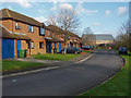
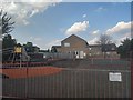
3
Service quarters
Service married quarters in Malta Road, Deepcut. Looking east from just outside the square, as close as I felt it wise to get with a camera.
Image: © Ron Strutt
Taken: 29 Sep 2005
0.11 miles
4
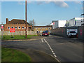
Newfoundland Road, Blackdown
The junction of Canada Road with Newfoundland Road. On the right is a new housing development on the site of the Blackdown Primary School.
Image: © Alan Hunt
Taken: 28 Dec 2014
0.12 miles
6
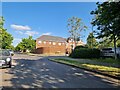
Navigating northwards up the Basher (24)
Junction of Earl of Chester Drive and Suffolk Court
Image: © Basher Eyre
Taken: 6 Jun 2023
0.16 miles
7
Dettigen housing estate
The new houses on the site of the former Dettigen Barracks at Blackdown near Camberley.
Image: © Alan Hunt
Taken: 20 Dec 2014
0.17 miles
8
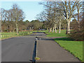
Access road, Former Dettigen Barracks
The access road to the sports fields at the former Dettigen barracks at Blackdown.
Image: © Alan Hunt
Taken: 20 Dec 2014
0.17 miles
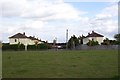
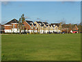
9
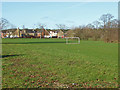
Recreation Ground, Dettingen estate
The large recreation area, formerly the Dettigen Barracks sports ground with the new built Dettigen estate in the background.
Image: © Alan Hunt
Taken: 20 Dec 2014
0.19 miles
10
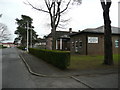
The Royal Logistics Corps Museum
An unassuming building on the Deepcut estate.
Image: © Jonathan Billinger
Taken: 26 Mar 2008
0.19 miles