IMAGES TAKEN NEAR TO
Aisne Road, CAMBERLEY, GU16 6SS
Introduction
This page details the photographs taken nearby to Aisne Road, GU16 6SS by members of the Geograph project.
The Geograph project started in 2005 with the aim of publishing, organising and preserving representative images for every square kilometre of Great Britain, Ireland and the Isle of Man.

There are currently over 7.5m images from over14,400 individuals and you can help contribute to the project by visiting https://www.geograph.org.uk
Image Map (Loading...)


Getting Data...Please wait
Leaflet Map data © OpenStreetMap
Images are licensed for reuse under creativecommons.org/licenses/by-sa/2.0
Notes
- Clicking on the map will re-center to the selected point.
- The higher the marker number, the further away the image location is from the centre of the postcode.
Image Listing (18 Images Found)
Images are licensed for reuse under creativecommons.org/licenses/by-sa/2.0
Image
Details
Distance
1
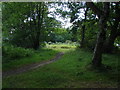
Colony Gate
The wooded scrubland that separates the backs of the houses on Minorca Road and Ainse Road.
Image: © Alan Hunt
Taken: 17 Jul 2010
0.03 miles
2
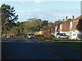
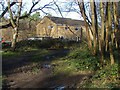
Aisne Road, Blackdown
One of the former military housing estates near the Blackdown Barracks complex.
Image: © Alan Hunt
Taken: 20 Dec 2014
0.05 miles
3
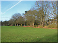
Edge of the sports ground
The tree line between the Dettingen sports ground and the houses on Ainse Road.
Image: © Alan Hunt
Taken: 20 Dec 2014
0.08 miles
4
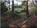
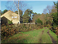
Woods near Colony Gate
The woods near Colony Gate with one of the houses on Minorca Road in the background.
Image: © Alan Hunt
Taken: 20 Dec 2014
0.09 miles
5
Woods near Colony Gate
The woods between Minorca Road and the Pirbright Range fence with one of the houses on Minorca Road in the background.
Image: © Alan Hunt
Taken: 20 Dec 2014
0.09 miles
6
Colony Gate
Scrub at the back of the houses on Minorca Road, Deepcut. These were part of the large army housing estates to the east of Deepcut Bridge Road.
Image: © Alan Hunt
Taken: 17 Jul 2010
0.10 miles
7
Pirbright range fence line
The range fence running through the pine woods near Colony Gate.
Image: © Alan Hunt
Taken: 20 Dec 2014
0.13 miles
8
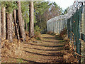
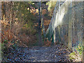
Track from Colony Gate
The track from Colony Gate running behind the houses on Minorca Road.
Image: © Alan Hunt
Taken: 20 Dec 2014
0.13 miles
9
Gully on Chobham Ridges
The fence line of the Pirbright Range cuts across a number of steep sided gullies between Mainstone Hill and Redroad Hill.
Image: © Alan Hunt
Taken: 20 Dec 2014
0.14 miles
10
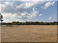
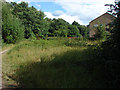
Sports Ground
Large open grassland close to the Chobham Ridges.
Image: © James Emmans
Taken: 11 Aug 2020
0.15 miles