IMAGES TAKEN NEAR TO
Old Guildford Road, CAMBERLEY, GU16 6PQ
Introduction
This page details the photographs taken nearby to Old Guildford Road, GU16 6PQ by members of the Geograph project.
The Geograph project started in 2005 with the aim of publishing, organising and preserving representative images for every square kilometre of Great Britain, Ireland and the Isle of Man.

There are currently over 7.5m images from over14,400 individuals and you can help contribute to the project by visiting https://www.geograph.org.uk
Image Map
Images are licensed for reuse under creativecommons.org/licenses/by-sa/2.0
Notes
- Clicking on the map will re-center to the selected point.
- The higher the marker number, the further away the image location is from the centre of the postcode.
Image Listing (6 Images Found)
Images are licensed for reuse under creativecommons.org/licenses/by-sa/2.0
Image
Details
Distance
1
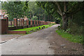
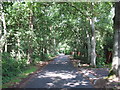
The Old Guildford Road
New build houses along the Old Guildford Road just outside the military training area.
Image: © Alan Hunt
Taken: 23 Aug 2015
0.11 miles
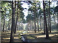
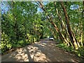
3
Track, Ash training area
A track through the pine woods that cover most of the military training area north of Mytchett Place Road.
Image: © Alan Hunt
Taken: 23 Aug 2015
0.13 miles
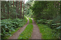
4
Footpath from Old Guildford Road to Deepcut Bridges
Image: © don cload
Taken: 30 Jul 2009
0.14 miles
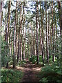
5
The Old Guildford Road
Part of the Old Guildford Road, surfaced up to this point.
Image: © don cload
Taken: 30 Jul 2009
0.15 miles
6
Navigating northwards up the Basher (22)
Looking south-east on the Old Guildford Road
Image: © Basher Eyre
Taken: 6 Jun 2023
0.20 miles