IMAGES TAKEN NEAR TO
Wynfields, CAMBERLEY, GU16 6DY
Introduction
This page details the photographs taken nearby to Wynfields, GU16 6DY by members of the Geograph project.
The Geograph project started in 2005 with the aim of publishing, organising and preserving representative images for every square kilometre of Great Britain, Ireland and the Isle of Man.

There are currently over 7.5m images from over14,400 individuals and you can help contribute to the project by visiting https://www.geograph.org.uk
Image Map (Loading...)


Getting Data...Please wait
Leaflet Map data © OpenStreetMap
Images are licensed for reuse under creativecommons.org/licenses/by-sa/2.0
Notes
- Clicking on the map will re-center to the selected point.
- The higher the marker number, the further away the image location is from the centre of the postcode.
Image Listing (19 Images Found)
Images are licensed for reuse under creativecommons.org/licenses/by-sa/2.0
Image
Details
Distance
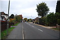
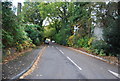
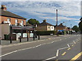
1
Mytchett Road
Business premises fronting onto Mytchett Road.
Image: © Alan Hunt
Taken: 13 Sep 2012
0.07 miles
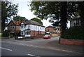
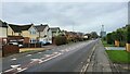
7
Mytchett Road
Mychett Road near its junction with Coleford Bridge Road.
Image: © Alan Hunt
Taken: 13 Sep 2012
0.14 miles
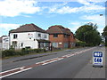
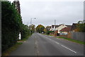
8
Mytchett Road
An indian restaurant on the junction of Rorkes Drift, a short residential road off Mytchett Road.
Image: © Alan Hunt
Taken: 13 Sep 2012
0.14 miles
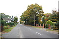
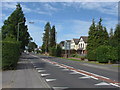
9
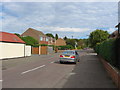
Rorkes Drift
A residential road off Mytchett Road.
Image: © Alan Hunt
Taken: 13 Sep 2012
0.15 miles