IMAGES TAKEN NEAR TO
Salisbury Terrace, CAMBERLEY, GU16 6DB
Introduction
This page details the photographs taken nearby to Salisbury Terrace, GU16 6DB by members of the Geograph project.
The Geograph project started in 2005 with the aim of publishing, organising and preserving representative images for every square kilometre of Great Britain, Ireland and the Isle of Man.

There are currently over 7.5m images from over14,400 individuals and you can help contribute to the project by visiting https://www.geograph.org.uk
Image Map
Images are licensed for reuse under creativecommons.org/licenses/by-sa/2.0
Notes
- Clicking on the map will re-center to the selected point.
- The higher the marker number, the further away the image location is from the centre of the postcode.
Image Listing (72 Images Found)
Images are licensed for reuse under creativecommons.org/licenses/by-sa/2.0
Image
Details
Distance
1
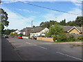
Salisbury Grove
The view along Salisbury Grove, a residential road that runs parallel with the southern end of Mytchett Road.
Image: © Alan Hunt
Taken: 13 Sep 2012
0.05 miles
3
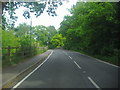
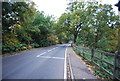
Mytchett Place Road heading for railway bridge
Image: © David Howard
Taken: 1 May 2011
0.07 miles
4
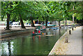
Rowing on the Basingstoke Canal
A couple of these hired from the boathouse in the background plus two paddleboarders were the only things I saw on the move today on the Basingstoke Canal.
Summer 2022 and the canal is drying up in this year's drought. Larger boats are grounded on their moorings. The normal water level can be seen on the far bank where the brown line comes to.
Image: © Des Blenkinsopp
Taken: 4 Aug 2022
0.07 miles
5
Swing Bridge, Basingstoke Canal Visitors Centre
Image: © N Chadwick
Taken: 13 Apr 2013
0.07 miles
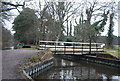
6
Swing Bridge at the Basingstoke Canal Visitor Centre
The manually operated swing bridge at the Basingstoke Canal's visitor centre.
Image: © Len Williams
Taken: 22 Apr 2013
0.07 miles
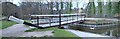
7

Swingbridge across the Basingstoke Canal
Providing access to and from the Visitor centre, cafe and campsite at Mytchett, which are all on the non-towpath side.
Image: © Christine Johnstone
Taken: 24 Mar 2012
0.07 miles
8
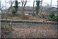
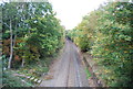
Line to Frimley
The line through Frimley is a link between the Waterloo-Reading line at Ascot and the Waterloo-Alton line at Ash Vale.
Image: © N Chadwick
Taken: 13 Apr 2013
0.07 miles