IMAGES TAKEN NEAR TO
Jubilee Road, CAMBERLEY, GU16 6BE
Introduction
This page details the photographs taken nearby to Jubilee Road, GU16 6BE by members of the Geograph project.
The Geograph project started in 2005 with the aim of publishing, organising and preserving representative images for every square kilometre of Great Britain, Ireland and the Isle of Man.

There are currently over 7.5m images from over14,400 individuals and you can help contribute to the project by visiting https://www.geograph.org.uk
Image Map (Loading...)


Getting Data...Please wait
Leaflet Map data © OpenStreetMap
Images are licensed for reuse under creativecommons.org/licenses/by-sa/2.0
Notes
- Clicking on the map will re-center to the selected point.
- The higher the marker number, the further away the image location is from the centre of the postcode.
Image Listing (68 Images Found)
Images are licensed for reuse under creativecommons.org/licenses/by-sa/2.0
Image
Details
Distance
5
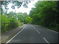
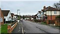
Mytchett Place Road heading for railway bridge
Image: © David Howard
Taken: 1 May 2011
0.08 miles
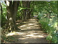
6
Towpath on the Basingstoke Canal
The towpath is generally in good order, and wide enough for the many cyclists, runners and walkers that use it.
Image: © Christine Johnstone
Taken: 24 Mar 2012
0.08 miles
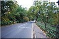
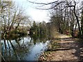
7
Basingstoke Canal
The towpath approaching the Guildford Road bridge.
Image: © Alan Hunt
Taken: 13 Sep 2012
0.09 miles
8
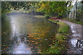
Rainy day on the Basingstoke Canal at Mytchett
Image: © David Martin
Taken: 24 Oct 2019
0.09 miles
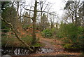
10
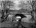
Mytchett Place Bridge, Basingstoke Canal
Seen from the south in 1979.
Image: © Dr Neil Clifton
Taken: 4 Mar 1979
0.09 miles