IMAGES TAKEN NEAR TO
Grayswood Drive, CAMBERLEY, GU16 6AP
Introduction
This page details the photographs taken nearby to Grayswood Drive, GU16 6AP by members of the Geograph project.
The Geograph project started in 2005 with the aim of publishing, organising and preserving representative images for every square kilometre of Great Britain, Ireland and the Isle of Man.

There are currently over 7.5m images from over14,400 individuals and you can help contribute to the project by visiting https://www.geograph.org.uk
Image Map
Images are licensed for reuse under creativecommons.org/licenses/by-sa/2.0
Notes
- Clicking on the map will re-center to the selected point.
- The higher the marker number, the further away the image location is from the centre of the postcode.
Image Listing (58 Images Found)
Images are licensed for reuse under creativecommons.org/licenses/by-sa/2.0
Image
Details
Distance
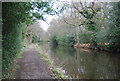
1
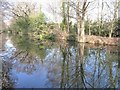
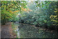
Reflections along the Basingstoke Canal
The canal travels through a corridor of mature trees.
Image: © Christine Johnstone
Taken: 24 Mar 2012
0.04 miles
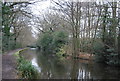
4
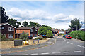
Grayswood Drive, Mytchett
Quite a long residential cul de sac between the railway and the Basingstoke Canal.
Image: © Des Blenkinsopp
Taken: 4 Aug 2022
0.05 miles
6
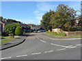
Grayswood drive
Grayswood Drive, a residential road that runs parallel with the Basingstoke canal, from its junction with Mytchett Lake Road.
Image: © Alan Hunt
Taken: 13 Sep 2012
0.06 miles
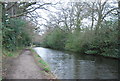
8
Mytchett Lake Road Bridge, Basingstoke Canal
Image: © N Chadwick
Taken: 13 Apr 2013
0.08 miles
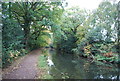
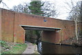
10
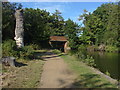
Mytchett Place Bridge
A view of the bridge carrying Mytchett Lake Road over the Basingstoke Canal.
Image: © Alan Hunt
Taken: 13 Sep 2012
0.08 miles