IMAGES TAKEN NEAR TO
Dawnay Road, CAMBERLEY, GU15 4LR
Introduction
This page details the photographs taken nearby to Dawnay Road, GU15 4LR by members of the Geograph project.
The Geograph project started in 2005 with the aim of publishing, organising and preserving representative images for every square kilometre of Great Britain, Ireland and the Isle of Man.

There are currently over 7.5m images from over14,400 individuals and you can help contribute to the project by visiting https://www.geograph.org.uk
Image Map
Images are licensed for reuse under creativecommons.org/licenses/by-sa/2.0
Notes
- Clicking on the map will re-center to the selected point.
- The higher the marker number, the further away the image location is from the centre of the postcode.
Image Listing (17 Images Found)
Images are licensed for reuse under creativecommons.org/licenses/by-sa/2.0
Image
Details
Distance
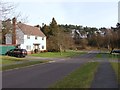
1
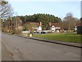
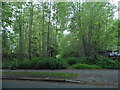
Dawnay Road
1990s houses on the south side of Dawnay Road. This road runs to the back entrance of the Military Staff College.
Image: © Alan Hunt
Taken: 18 Feb 2013
0.05 miles
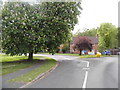
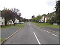
2
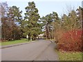
Dawnay Road, Camberley
The view along Dawney Road. The Army housing to the north was built in the early 1960s while the private housing to the south dates from the 1990s
Image: © Alan Hunt
Taken: 18 Feb 2013
0.10 miles
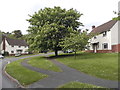
3
Dawnay Road
The close of new-built houses at the western end of estate. Beyond this point is the closed area of the Military Staff College.
Image: © Alan Hunt
Taken: 18 Feb 2013
0.13 miles
4
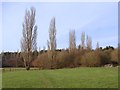
Barossa Common
A line of Lombardy Poplars on the former playing fields. On the far right by the end of the fence is the footpath that goes to Dawnay Road.
Image: © Alan Hunt
Taken: 18 Feb 2013
0.15 miles
5
The entrance to Broadmoor Bottom on Kings Ride
Image: © David Howard
Taken: 17 May 2015
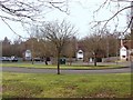
0.17 miles
7
Roundabout on Matthews Road, Camberley
Image: © David Howard
Taken: 17 May 2015
0.18 miles
8
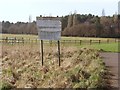
Barossa Common
Old signs on the former sports grounds of the Sandhurst College. The area is still owned by the MOD but has been fenced in for livestock.
Image: © Alan Hunt
Taken: 18 Feb 2013
0.19 miles
10
Matthews Road
Matthews Road looking towards the junction with King's Ride.
Image: © Alan Hunt
Taken: 18 Feb 2013
0.21 miles