IMAGES TAKEN NEAR TO
Diamond Ridge, CAMBERLEY, GU15 4LD
Introduction
This page details the photographs taken nearby to Diamond Ridge, GU15 4LD by members of the Geograph project.
The Geograph project started in 2005 with the aim of publishing, organising and preserving representative images for every square kilometre of Great Britain, Ireland and the Isle of Man.

There are currently over 7.5m images from over14,400 individuals and you can help contribute to the project by visiting https://www.geograph.org.uk
Image Map
Images are licensed for reuse under creativecommons.org/licenses/by-sa/2.0
Notes
- Clicking on the map will re-center to the selected point.
- The higher the marker number, the further away the image location is from the centre of the postcode.
Image Listing (17 Images Found)
Images are licensed for reuse under creativecommons.org/licenses/by-sa/2.0
Image
Details
Distance
1
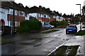
Diamond Ridge
Taken immediately after a very heavy shower of rain.
Image: © David Martin
Taken: 16 Jan 2014
0.04 miles
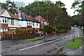
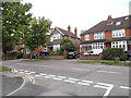
3
College Ride, Camberley
At the Diamond Ridge and College Close crossroads.
Image: © Andrew Smith
Taken: 11 Feb 2006
0.10 miles
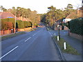
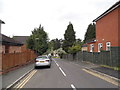
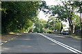
4
College Ride, Camberley
Heading north-east away from the Royal Military Academy from which it gets its name.
Image: © Andrew Smith
Taken: 18 Apr 2021
0.13 miles
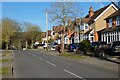
5
College Ride at the junction of Whitehill Close
Image: © David Howard
Taken: 17 May 2015
0.13 miles
6
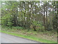
Woods by Upper College Ride, Camberley
Image: © David Howard
Taken: 17 May 2015
0.15 miles
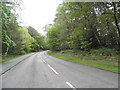
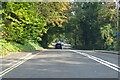
9
A30 London Road, Camberley
Towards London.
Image: © Robin Webster
Taken: 26 Sep 2021
0.16 miles
10
A30 London Road, Camberley
Towards London.
Image: © Robin Webster
Taken: 26 Sep 2021
0.18 miles