IMAGES TAKEN NEAR TO
Paschal Road, CAMBERLEY, GU15 4EG
Introduction
This page details the photographs taken nearby to Paschal Road, GU15 4EG by members of the Geograph project.
The Geograph project started in 2005 with the aim of publishing, organising and preserving representative images for every square kilometre of Great Britain, Ireland and the Isle of Man.

There are currently over 7.5m images from over14,400 individuals and you can help contribute to the project by visiting https://www.geograph.org.uk
Image Map
Images are licensed for reuse under creativecommons.org/licenses/by-sa/2.0
Notes
- Clicking on the map will re-center to the selected point.
- The higher the marker number, the further away the image location is from the centre of the postcode.
Image Listing (34 Images Found)
Images are licensed for reuse under creativecommons.org/licenses/by-sa/2.0
Image
Details
Distance
1
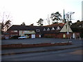
St Peter and St John's RC Church, Camberley
Image: © Andrew Smith
Taken: 11 Feb 2006
0.06 miles

5
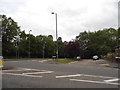
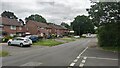
Caesars Camp Road at the junction of London Road
Image: © David Howard
Taken: 17 May 2015
0.10 miles
6

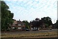
Old Boundary Marker on the A30 London Road
The Darby Stone, on the A30 London Road near the junction with Gibbet Lane. In the former Frimley parish, now an unparished area in Surrey Heath district. Reported to have marked a gibbet and to have been connected with Parson Darby, A Stone is marked at Image on the 1897 25" map.
Milestone Society National ID: SY_CAMBY02zz
Image: © T Dodds
Taken: Unknown
0.12 miles


9
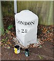
Old Milestone by the A30, London Road, Camberley
Carved stone post by the A30, in parish of Camberley (Surrey Heath District), by traffic lights at junction of London Road with Caesar's Camp Road, beyond roadside rails, on grass between path and wooden fence, on South South-east side of road. Hartford limestone diamond, erected by the Basingstoke, Hartfordbridge & Blackwater (and Odiham) Turnpike Trust in the 19th century.
Inscription reads:-
: Hartford Bridge / 7¾ : : LONDON / 28 : : Bagshot / 1¾ :
Carved benchmark on mid left.
Milestone Society National ID: SY_LE28.
Image: © Milestone Society
Taken: 15 Sep 2017
0.12 miles