IMAGES TAKEN NEAR TO
Woodbridge Drive, CAMBERLEY, GU15 3TN
Introduction
This page details the photographs taken nearby to Woodbridge Drive, GU15 3TN by members of the Geograph project.
The Geograph project started in 2005 with the aim of publishing, organising and preserving representative images for every square kilometre of Great Britain, Ireland and the Isle of Man.

There are currently over 7.5m images from over14,400 individuals and you can help contribute to the project by visiting https://www.geograph.org.uk
Image Map
Images are licensed for reuse under creativecommons.org/licenses/by-sa/2.0
Notes
- Clicking on the map will re-center to the selected point.
- The higher the marker number, the further away the image location is from the centre of the postcode.
Image Listing (20 Images Found)
Images are licensed for reuse under creativecommons.org/licenses/by-sa/2.0
Image
Details
Distance
1
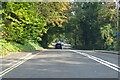
A30 London Road, Camberley
Towards London.
Image: © Robin Webster
Taken: 26 Sep 2021
0.06 miles
3
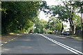
A30 London Road, Camberley
Towards London.
Image: © Robin Webster
Taken: 26 Sep 2021
0.09 miles
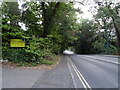
4
Diamond Ridge
Taken immediately after a very heavy shower of rain.
Image: © David Martin
Taken: 16 Jan 2014
0.15 miles
5
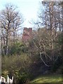
The Obelisk and Knoll
The Camberley Obelisk is situated on 'The Knoll', a hill to the East of the town. Before the town was established the Knoll was probably clear of trees and the Obelisk would have been visible for miles. Currently it is only in winter, when there is little foliage on the trees can the Obelisk be seen from the A30. The area around the Knoll has been landscaped and is now 'Camberley Park'. For a closer view of the Obelisk refer to picture Image
Image: © Len Williams
Taken: 26 Mar 2012
0.17 miles
6
Camberley Obelisk
The Camberley Obelisk on the Knoll as seen from the roof of the town centre car park. In summer it is virtually invisible due to the tree cover. For a closer view of the Obelisk refer to picture Image
Image: © Len Williams
Taken: 29 Mar 2012
0.17 miles
7
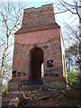
The Obelisk, Camberley
The brick tower known as The Obelisk is a Folly located East of Camberley. Only about 9.4 metres (30 feet) now remain, but it is estimated that it originally stood about 30.5 metres (100 feet) high. A wooden staircase inside allowed access to the top, and the building was probably divided into several storeys. The brickwork is about 1.5 metres (almost 5 feet) thick in parts. The structure occupies rising ground close to the A30, once the main turnpike road from London to Exeter. It was built in around 1765-70 by John Norris of Hawley Place, about 2 miles away to the west. The surrounding area was then open heathland, and on a clear day it was possible to see for many miles. Camberley itself did not then exist, and the Obelisk was a notable landmark, as early maps show.For a view of the Obelisk from Camberley refer to picture Image
Image: © Len Williams
Taken: 26 Mar 2012
0.17 miles
8
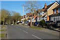
College Ride, Camberley
At the Diamond Ridge and College Close crossroads.
Image: © Andrew Smith
Taken: 11 Feb 2006
0.18 miles
9
College Ride, Camberley
Heading north-east away from the Royal Military Academy from which it gets its name.
Image: © Andrew Smith
Taken: 18 Apr 2021
0.19 miles
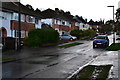
10
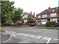
College Ride at the junction of Whitehill Close
Image: © David Howard
Taken: 17 May 2015
0.19 miles