IMAGES TAKEN NEAR TO
Woodlands Road, CAMBERLEY, GU15 3ND
Introduction
This page details the photographs taken nearby to Woodlands Road, GU15 3ND by members of the Geograph project.
The Geograph project started in 2005 with the aim of publishing, organising and preserving representative images for every square kilometre of Great Britain, Ireland and the Isle of Man.

There are currently over 7.5m images from over14,400 individuals and you can help contribute to the project by visiting https://www.geograph.org.uk
Image Map
Images are licensed for reuse under creativecommons.org/licenses/by-sa/2.0
Notes
- Clicking on the map will re-center to the selected point.
- The higher the marker number, the further away the image location is from the centre of the postcode.
Image Listing (6 Images Found)
Images are licensed for reuse under creativecommons.org/licenses/by-sa/2.0
Image
Details
Distance
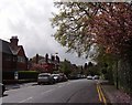
2
Chapel Road
Camberley Baptist Church is at the end of the road.
Image: © James Emmans
Taken: 26 May 2021
0.16 miles
3
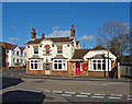
The Four Horse Shoes
The Four Horse Shoes inn on the Frimley Road at the junction with the Avenue.
Image: © Alan Hunt
Taken: 13 Feb 2014
0.18 miles
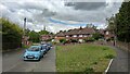
4
Social housing in Avenue Sucy
These flats were built in the late 60s like many buildings of the day, were built with flat roofs. Less than 20 years later pitched roofs were built at great cost.
Image: © dinglefoot
Taken: 29 Jul 2005
0.23 miles
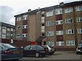
5
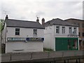
Unhappy looking buildings
In London Road, Camberley.
Image: © David960
Taken: 31 May 2014
0.24 miles
6
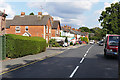
Vale Road, Camberley
One of the roads leading west off the Frimley Road towards the York Town industrial area.
Image: © Alan Hunt
Taken: 20 Sep 2015
0.25 miles