IMAGES TAKEN NEAR TO
Admiralty Way, CAMBERLEY, GU15 3DT
Introduction
This page details the photographs taken nearby to Admiralty Way, GU15 3DT by members of the Geograph project.
The Geograph project started in 2005 with the aim of publishing, organising and preserving representative images for every square kilometre of Great Britain, Ireland and the Isle of Man.

There are currently over 7.5m images from over14,400 individuals and you can help contribute to the project by visiting https://www.geograph.org.uk
Image Map
Images are licensed for reuse under creativecommons.org/licenses/by-sa/2.0
Notes
- Clicking on the map will re-center to the selected point.
- The higher the marker number, the further away the image location is from the centre of the postcode.
Image Listing (37 Images Found)
Images are licensed for reuse under creativecommons.org/licenses/by-sa/2.0
Image
Details
Distance
1
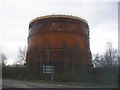
Gasometer, York Town
One of two gasometers beside the Blackater Valley Road.
Image: © don cload
Taken: 23 Feb 2009
0.05 miles
2
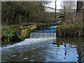
Drain outflow, York Town
A drain outflow from the York Town industrial area into the Blackwater River.
Image: © Alan Hunt
Taken: 28 Jan 2014
0.08 miles
5
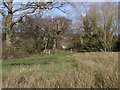
Blackwater Valley Path
The gate at the northern end of Hawley Meadows on the banks of the River Blackwater. The industrial units of York Town can be seen through the trees in the background.
Image: © Alan Hunt
Taken: 28 Jan 2014
0.11 miles
6
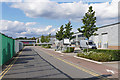
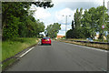
Doman Road, Camberley
Doman Road in the York Town industrial area to the west of Cambereley.
Image: © Alan Hunt
Taken: 20 Sep 2015
0.12 miles
7
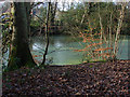
Pond by the River Blackwater
A small pond beside the River Blackwater with the houses of Blackwater through the treesbehind.
Image: © Alan Hunt
Taken: 28 Jan 2014
0.13 miles
9
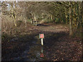
Pipeline marker
A marker on the gas pipeline that runs through the woods beside the railway line south of Blackwater Station.
Image: © Alan Hunt
Taken: 28 Jan 2014
0.13 miles
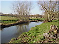
10
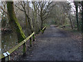
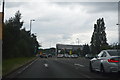
Blackwater Valley Path
The long distance path that follows the course of the River Blackwater.
Image: © Alan Hunt
Taken: 28 Jan 2014
0.14 miles