IMAGES TAKEN NEAR TO
Balfour Court, CAMBERLEY, GU15 3DQ
Introduction
This page details the photographs taken nearby to Balfour Court, GU15 3DQ by members of the Geograph project.
The Geograph project started in 2005 with the aim of publishing, organising and preserving representative images for every square kilometre of Great Britain, Ireland and the Isle of Man.

There are currently over 7.5m images from over14,400 individuals and you can help contribute to the project by visiting https://www.geograph.org.uk
Image Map
Images are licensed for reuse under creativecommons.org/licenses/by-sa/2.0
Notes
- Clicking on the map will re-center to the selected point.
- The higher the marker number, the further away the image location is from the centre of the postcode.
Image Listing (108 Images Found)
Images are licensed for reuse under creativecommons.org/licenses/by-sa/2.0
Image
Details
Distance
3
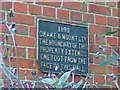
Drake & Mount Boundary Plaque
This plaque defines the boundary limit of the Drake & Mount Coal Merchants premises. The plaque is all that remains of this company. For a picture of the building refer to Image
Image: © Len Williams
Taken: 20 Nov 2014
0.04 miles
4
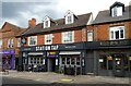
The Station Tap, Camberley
On High Street.
See Image] for sign.
Image: © JThomas
Taken: 27 Jul 2022
0.04 miles
5
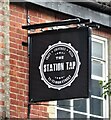
Sign for the Station Tap, Camberley
See Image] for context.
Image: © JThomas
Taken: 27 Jul 2022
0.04 miles
6
Troy Grill Meze Bar, Camberley
On High Street.
See Image] for sign.
Image: © JThomas
Taken: 27 Jul 2022
0.04 miles
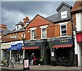
7

Signs for Troy Grill Meze Bar, Camberley
See Image] for context.
Image: © JThomas
Taken: 27 Jul 2022
0.04 miles
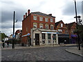
8
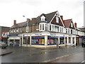
Camberley: Thomas Cook, High Street (Listed Building)
There is only one Nationally Listed Building in Camberley town centre and this is it. The English Heritage website describes it thus:-
"Numbers 72-74 High Street (Anglia Building Society). House, now offices. C17 altered in C19. Timber framed with rendered cladding below, exposed to eaves with rendered infilling; plain tiled roof. Two storeys, 3 framed bays with two 3-light metal diamond pane leaded casement windows across first floor. Two square bay shop windows to ground floor with "Gothick" arched head glazing bars. Two half glazed doors to centre in similar panelled surrounds under blocked transome lights with flanking half pilasters under triglyph capitals. Bracket between doors supporting fascia boards. Flat lintelled throughway to right end."
The Anglia Building Society has long since been subsumed into the Nationwide, while the building next door, 66-68 High Street and occupied by Illuminations, although not listed, appears to be of a similar provenance. The faded road name plate on the building wall above the Thomas Cook sign states "Princess Way" although old Ordnance Survey maps up to 1973 at least call the road "Princess Street".
Image: © Nigel Cox
Taken: 12 Jun 2011
0.04 miles
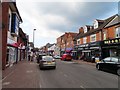
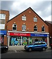
10
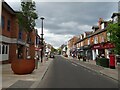
High Street, Camberley
Showing position of Postbox No. GU15 36.
See Image] for postbox.
Image: © JThomas
Taken: 27 Jul 2022
0.05 miles