
IMAGES TAKEN NEAR TO
Portesbery Road, CAMBERLEY, GU15 3BZ
Introduction
This page details the photographs taken nearby to Portesbery Road, GU15 3BZ by members of the Geograph project.
The Geograph project started in 2005 with the aim of publishing, organising and preserving representative images for every square kilometre of Great Britain, Ireland and the Isle of Man.

There are currently over 7.5m images from over14,400 individuals and you can help contribute to the project by visiting https://www.geograph.org.uk
Image Map
Images are licensed for reuse under creativecommons.org/licenses/by-sa/2.0
Notes
- Clicking on the map will re-center to the selected point.
- The higher the marker number, the further away the image location is from the centre of the postcode.
Image Listing (70 Images Found)
Images are licensed for reuse under creativecommons.org/licenses/by-sa/2.0
Image
Details
Distance
1
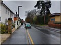
Portesbery Road
A road running parallel to the train tracks in Camberley. The large building to the right is Knoll Road multi-storey car park. The road has marked parking bays which allow parking for up to 2 hours for non permit holders. These are some of the closest free parking bays to the town centre.
Image: © Oscar Taylor
Taken: 31 Mar 2023
0.03 miles
2
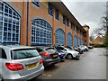
Permit parking off Portesbery Road
Permit parking for residents off Portesbery Road. Behind the parked cars is Knoll Road multi-storey car park. The permit parking car park is used as a cut-through for pedestrians going from Portesbery Road to Camberley town centre through the church car park (or vice versa).
Image: © Oscar Taylor
Taken: 31 Mar 2023
0.04 miles
3
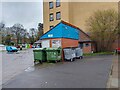
Public conveniences by Knoll Road car park
Public conveniences near to Camberley Theatre and Knoll Road multi-storey car park in Camberley.
Image: © Oscar Taylor
Taken: 31 Mar 2023
0.08 miles
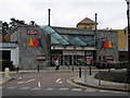
5
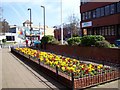
Camberley Theatre
Camberley theatre from the walkway which links it to the town centre. Behind the theatre is one of the car parks.
Image: © Len Williams
Taken: 29 Mar 2012
0.10 miles
6
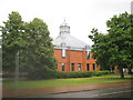
Camberley: High Cross Church
The church was completed in 1990 and was opened by the merging of the Methodist and United Reformed Churches in Camberley. The Church is on Knoll Road and its website is here http://www.highcross.org.uk/
Image: © Nigel Cox
Taken: 12 Jun 2011
0.10 miles
7
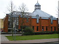
High Cross Church, Camberley
Close to the Camberley town centre, next to the Camberley Theatre.
Image: © don cload
Taken: 23 Feb 2009
0.10 miles
8
Camberley Library
Camberley library with a magnificent magnolia tree.
Image: © Len Williams
Taken: 29 Mar 2012
0.11 miles
9
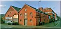
Drake & Mount Coal Merchants, Camberley
This building used to be the Camberley branch of Drake and Mount Coal Merchants whose head office was located at Bracknell. For details of a sign defining the boundary of the premises refer to picture Image
Image: © Len Williams
Taken: 20 Nov 2014
0.13 miles
10
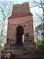
The Obelisk, Camberley
The brick tower known as The Obelisk is a Folly located East of Camberley. Only about 9.4 metres (30 feet) now remain, but it is estimated that it originally stood about 30.5 metres (100 feet) high. A wooden staircase inside allowed access to the top, and the building was probably divided into several storeys. The brickwork is about 1.5 metres (almost 5 feet) thick in parts. The structure occupies rising ground close to the A30, once the main turnpike road from London to Exeter. It was built in around 1765-70 by John Norris of Hawley Place, about 2 miles away to the west. The surrounding area was then open heathland, and on a clear day it was possible to see for many miles. Camberley itself did not then exist, and the Obelisk was a notable landmark, as early maps show.For a view of the Obelisk from Camberley refer to picture Image
Image: © Len Williams
Taken: 26 Mar 2012
0.13 miles